Vierzon geodata
Vierzon (Centre) is a seat of a third-order administrative division; located in France in Europe/Paris (GMT+2) time zone. With population of 29,876 people, there are 272 cities with bigger population in this country. Compared to other cities in France, 52.7% of cities are located further ↑North; 56.2% of cities are located further →East and 59.7% of cities have higher elevation than Vierzon. Note1
Administrative division(s):
- Level 1: Centre
- Level 2: Cher
- Level 3: Arrondissement de Vierzon
- Level 4: Vierzon


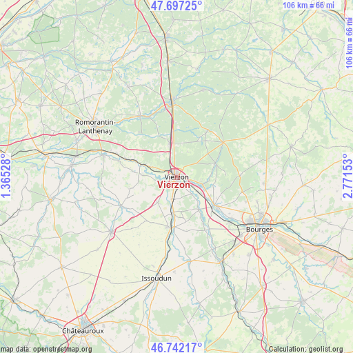
Vierzon GPS coordinates[2]
47° 13' 18.696" North, 2° 4' 6.24" East
| Map corner | latitude | longitude |
|---|---|---|
| Upper-left | 47.69725°, | 1.36528° |
| Center: | 47.22186°, | 2.0684° |
| Lower-right: | 46.74217°, | 2.77153° |
| Map W x H: | 106.2×106.2 km | = 66×66mi |
| max Lat: | 51.07786° ⇑52.7% North |
| Vierzon: | 47.22186° |
| min Lat: | ⇓47.3% South 41.3874° |
| min Long | Vierzon | max Long |
| -5.08615° | 2.0684° | 9.52242° |
| W 43.8%⇐ | ⇒56.2% E |
Elevation
Elevation of Vierzon is 103 m = 338 ft, and this is 90.7 m = 298 ft below average elevation for this country.
| Max E: |
2333 m = 7654 ft | 59.7% |
| Avg. | 193.7 m = 635 ft | |
| Vierzon | 103 m = 338 ft | |
Min E: |
-1 m = -3 ft | 40.3% |
See also: France elevation on elevation.city.
Geographical zone
Vierzon is located in North temperate zone (between Tropic of Cancer and the Arctic Circle). Distance of this North polar circle is 2150.6 km =1336.3 mi to North.| Distance of | km | miles | from Vierzon |
|---|---|---|---|
| North Pole | 4756.5 | 2955.6 | to North |
| Arctic Circle | 2150.6 | 1336.3 | to North |
| Tropic Cancer | 2644.7 | 1643.3 | to South |
| Equator | 5250.6 | 3262.6 | to South |


Nearby cities:
15 places around Vierzon: (largest is in red/bold)
• Allouis
13.6 km =8.5 mi,  117°
117°
• Châtres-sur-Cher
13.2 km =8.2 mi,  291°
291°
• Foëcy
8.7 km =5.4 mi,  125°
125°
• Genouilly
14.2 km =8.8 mi,  256°
256°
• Lury-sur-Arnon
10.6 km =6.6 mi,  184°
184°
• Massay
9.5 km =5.9 mi,  216°
216°
• Méreau
6.7 km =4.2 mi,  191°
191°
• Méry-sur-Cher
6.6 km =4.1 mi, 294°
• Quincy
12 km =7.5 mi,  145°
145°
• Saint-Georges-sur-la-Prée
10 km =6.2 mi,  272°
272°
• Saint-Hilaire-de-Court
4.1 km =2.5 mi,  243°
243°
• Theillay
10.5 km =6.5 mi,  348°
348°
• Thénioux
10.7 km =6.6 mi, 290°
• Vignoux-sur-Barangeon
8.2 km =5.1 mi,  106°
106°
• Vouzeron
12.3 km =7.6 mi,  69°
69°
Sources, notices
• [Note1] Compared only with cities in France existing in our database
• [Src1] Map data: © OpenStreetMap contributors (CC-BY-SA)
• [Src2] Other city data from geonames.org with taken over terms of usage.
• [Src3] Geographical zone / Annual Mean Temperature by Robert A. Rohde @ Wikipedia
