Garons geodata
Garons (Occitanie) is a populated place; located in France in Europe/Paris (GMT+2) time zone. With population of 4,019 people, there are 2442 cities with bigger population in this country. Compared to other cities in France, 89.5% of cities are located further ↑North; 71.5% of cities are located further ←West and 62.4% of cities have higher elevation than Garons. Note1
Administrative division(s):
- Level 1: Occitanie
- Level 2: Gard
- Level 3: Arrondissement de Nîmes
- Level 4: Garons


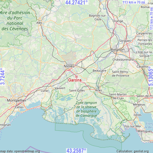
Garons GPS coordinates[2]
43° 46' 6.996" North, 4° 25' 39.108" East
| Map corner | latitude | longitude |
|---|---|---|
| Upper-left | 44.27421°, | 3.7244° |
| Center: | 43.76861°, | 4.42753° |
| Lower-right: | 43.2587°, | 5.13065° |
| Map W x H: | 112.9×112.9 km | = 70.2×70.2mi |
| max Lat: | 51.07786° ⇑89.5% North |
| Garons: | 43.76861° |
| min Lat: | ⇓10.5% South 41.3874° |
| min Long | Garons | max Long |
| -5.08615° | 4.42753° | 9.52242° |
| W 71.5%⇐ | ⇒28.5% E |
Elevation
Elevation of Garons is 96 m = 315 ft, and this is 97.7 m = 321 ft below average elevation for this country.
| Max E: |
2333 m = 7654 ft | 62.4% |
| Avg. | 193.7 m = 635 ft | |
| Garons | 96 m = 315 ft | |
Min E: |
-1 m = -3 ft | 37.6% |
See also: France elevation on elevation.city.
Geographical zone
Garons is located in North temperate zone (between Tropic of Cancer and the Arctic Circle). Distance of this Northern Tropic circle is 2260.7 km =1404.7 mi to South.| Distance of | km | miles | from Garons |
|---|---|---|---|
| North Pole | 5140.4 | 3194.1 | to North |
| Arctic Circle | 2534.6 | 1574.9 | to North |
| Tropic Cancer | 2260.7 | 1404.7 | to South |
| Equator | 4866.6 | 3024 | to South |


Nearby cities:
15 places around Garons: (largest is in red/bold)
• Aubord
9.4 km =5.8 mi,  262°
262°
• Beauvoisin
10.1 km =6.3 mi,  236°
236°
• Bellegarde
7.3 km =4.5 mi,  103°
103°
• Bernis
11.3 km =7 mi,  270°
270°
• Bouillargues
3.2 km =2 mi,  1°
1°
• Caissargues
4.8 km =3 mi,  307°
307°
• Générac
7.7 km =4.8 mi,  234°
234°
• Manduel
6.6 km =4.1 mi,  33°
33°
• Marguerittes
10.2 km =6.3 mi,  7°
7°
• Milhaud
9.7 km =6 mi,  284°
284°
• Nîmes
9.1 km =5.7 mi,  323°
323°
• Redessan
9 km =5.6 mi,  38°
38°
• Rodilhan
6.5 km =4 mi, 2°
• Saint-Gervasy
12.4 km =7.7 mi, 14°
• Saint-Gilles
10.2 km =6.3 mi,  178°
178°
Sources, notices
• [Note1] Compared only with cities in France existing in our database
• [Src1] Map data: © OpenStreetMap contributors (CC-BY-SA)
• [Src2] Other city data from geonames.org with taken over terms of usage.
• [Src3] Geographical zone / Annual Mean Temperature by Robert A. Rohde @ Wikipedia
