Dreux geodata
Dreux (Centre) is a seat of a third-order administrative division; located in France in Europe/Paris (GMT+2) time zone. With population of 31,058 people, there are 259 cities with bigger population in this country. Compared to other cities in France, 74% of cities are located further ↓South; 64.8% of cities are located further →East and 64.4% of cities have higher elevation than Dreux. Note1
Administrative division(s):
- Level 1: Centre
- Level 2: Département d'Eure-et-Loir
- Level 3: Arrondissement de Dreux
- Level 4: Dreux


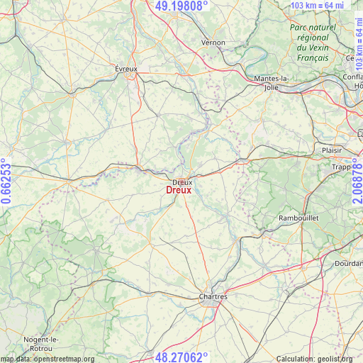
Dreux GPS coordinates[2]
48° 44' 11.364" North, 1° 21' 56.376" East
| Map corner | latitude | longitude |
|---|---|---|
| Upper-left | 49.19808°, | 0.66253° |
| Center: | 48.73649°, | 1.36566° |
| Lower-right: | 48.27062°, | 2.06878° |
| Map W x H: | 103.1×103.1 km | = 64.1×64.1mi |
| max Lat: | 51.07786° ⇑26% North |
| Dreux: | 48.73649° |
| min Lat: | ⇓74% South 41.3874° |
| min Long | Dreux | max Long |
| -5.08615° | 1.36566° | 9.52242° |
| W 35.2%⇐ | ⇒64.8% E |
Elevation
Elevation of Dreux is 91 m = 299 ft, and this is 102.7 m = 337 ft below average elevation for this country.
| Max E: |
2333 m = 7654 ft | 64.4% |
| Avg. | 193.7 m = 635 ft | |
| Dreux | 91 m = 299 ft | |
Min E: |
-1 m = -3 ft | 35.6% |
See also: France elevation on elevation.city.
Geographical zone
Dreux is located in North temperate zone (between Tropic of Cancer and the Arctic Circle). Distance of this North polar circle is 1982.2 km =1231.7 mi to North.| Distance of | km | miles | from Dreux |
|---|---|---|---|
| North Pole | 4588.1 | 2850.9 | to North |
| Arctic Circle | 1982.2 | 1231.7 | to North |
| Tropic Cancer | 2813.1 | 1748 | to South |
| Equator | 5419 | 3367.2 | to South |


Nearby cities:
15 places around Dreux: (largest is in red/bold)
• Abondant
7.7 km =4.8 mi,  44°
44°
• Charpont
6.6 km =4.1 mi,  128°
128°
• Cherisy
5.2 km =3.2 mi,  73°
73°
• Garnay
4.1 km =2.5 mi,  210°
210°
• Luray
3 km =1.9 mi, 126°
• Mesnil-sur-l’Estrée
6 km =3.7 mi,  308°
308°
• Montreuil
4.6 km =2.9 mi,  3°
3°
• Muzy
4.4 km =2.7 mi,  342°
342°
• Mézières-en-Drouais
4.5 km =2.8 mi,  107°
107°
• Saint-Georges-Motel
6.3 km =3.9 mi, 0°
• Saint-Germain-sur-Avre
7.8 km =4.8 mi,  293°
293°
• Sainte-Gemme-Moronval
3.6 km =2.2 mi,  86°
86°
• Tréon
7.2 km =4.5 mi,  203°
203°
• Vernouillet
1.8 km =1.1 mi,  170°
170°
• Vert-en-Drouais
5.8 km =3.6 mi,  296°
296°
Sources, notices
• [Note1] Compared only with cities in France existing in our database
• [Src1] Map data: © OpenStreetMap contributors (CC-BY-SA)
• [Src2] Other city data from geonames.org with taken over terms of usage.
• [Src3] Geographical zone / Annual Mean Temperature by Robert A. Rohde @ Wikipedia
