Luray geodata
Luray (Centre) is a populated place; located in France in Europe/Paris (GMT+2) time zone. With population of 1,360 people, there are 6763 cities with bigger population in this country. Compared to other cities in France, 73.7% of cities are located further ↓South; 64.3% of cities are located further →East and 50.3% of cities have lower elevation than Luray. Note1
Administrative division(s):
- Level 1: Centre
- Level 2: Département d'Eure-et-Loir
- Level 3: Arrondissement de Dreux
- Level 4: Luray


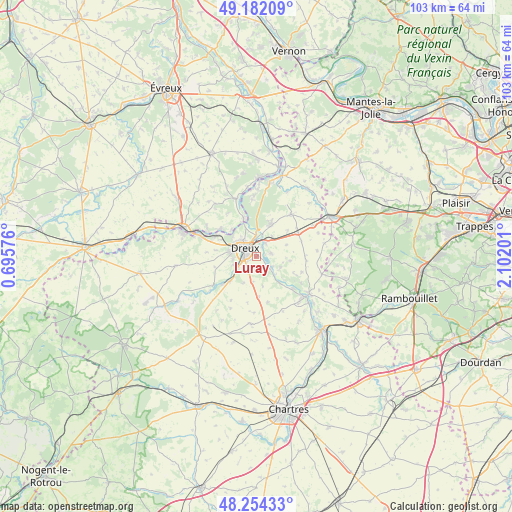
Luray GPS coordinates[2]
48° 43' 13.26" North, 1° 23' 56.004" East
| Map corner | latitude | longitude |
|---|---|---|
| Upper-left | 49.18209°, | 0.69576° |
| Center: | 48.72035°, | 1.39889° |
| Lower-right: | 48.25433°, | 2.10201° |
| Map W x H: | 103.2×103.2 km | = 64.1×64.1mi |
| max Lat: | 51.07786° ⇑26.3% North |
| Luray: | 48.72035° |
| min Lat: | ⇓73.7% South 41.3874° |
| min Long | Luray | max Long |
| -5.08615° | 1.39889° | 9.52242° |
| W 35.7%⇐ | ⇒64.3% E |
Elevation
Elevation of Luray is 133 m = 436 ft, and this is 60.7 m = 199 ft below average elevation for this country.
| Max E: |
2333 m = 7654 ft | 49.7% |
| Avg. | 193.7 m = 635 ft | |
| Luray | 133 m = 436 ft | |
Min E: |
-1 m = -3 ft | 50.3% |
See also: France elevation on elevation.city.
Geographical zone
Luray is located in North temperate zone (between Tropic of Cancer and the Arctic Circle). Distance of this North polar circle is 1984 km =1232.8 mi to North.| Distance of | km | miles | from Luray |
|---|---|---|---|
| North Pole | 4589.9 | 2852 | to North |
| Arctic Circle | 1984 | 1232.8 | to North |
| Tropic Cancer | 2811.3 | 1746.9 | to South |
| Equator | 5417.2 | 3366.1 | to South |


Nearby cities:
15 places around Luray: (largest is in red/bold)
• Abondant
7.9 km =4.9 mi,  22°
22°
• Charpont
3.6 km =2.2 mi,  130°
130°
• Cherisy
4.2 km =2.6 mi,  37°
37°
• Dreux
3 km =1.9 mi,  306°
306°
• Garnay
4.9 km =3 mi,  249°
249°
• Marville-Moutiers-Brûlé
6 km =3.7 mi,  179°
179°
• Montreuil
6.7 km =4.2 mi,  341°
341°
• Muzy
7.1 km =4.4 mi,  327°
327°
• Mézières-en-Drouais
1.9 km =1.2 mi,  77°
77°
• Ouerre
5.4 km =3.4 mi,  114°
114°
• Saint-Georges-Motel
8.5 km =5.3 mi, 343°
• Sainte-Gemme-Moronval
2.3 km =1.4 mi,  29°
29°
• Tréon
7.2 km =4.5 mi,  227°
227°
• Vernouillet
2.2 km =1.4 mi,  271°
271°
• Villemeux-sur-Eure
7.2 km =4.5 mi,  137°
137°
Sources, notices
• [Note1] Compared only with cities in France existing in our database
• [Src1] Map data: © OpenStreetMap contributors (CC-BY-SA)
• [Src2] Other city data from geonames.org with taken over terms of usage.
• [Src3] Geographical zone / Annual Mean Temperature by Robert A. Rohde @ Wikipedia
