Vernouillet geodata
Vernouillet (Centre) is a populated place; located in France in Europe/Paris (GMT+2) time zone. With population of 11,783 people, there are 816 cities with bigger population in this country. Compared to other cities in France, 73.7% of cities are located further ↓South; 64.7% of cities are located further →East and 50.9% of cities have higher elevation than Vernouillet. Note1
Administrative division(s):
- Level 1: Centre
- Level 2: Département d'Eure-et-Loir
- Level 3: Arrondissement de Dreux
- Level 4: Vernouillet


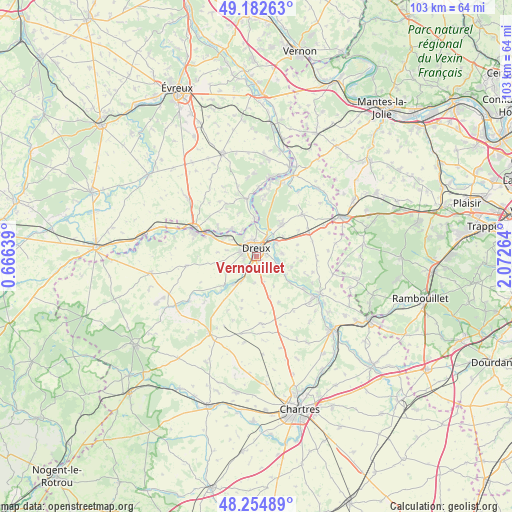
Vernouillet GPS coordinates[2]
48° 43' 15.24" North, 1° 22' 10.236" East
| Map corner | latitude | longitude |
|---|---|---|
| Upper-left | 49.18263°, | 0.66639° |
| Center: | 48.7209°, | 1.36951° |
| Lower-right: | 48.25489°, | 2.07264° |
| Map W x H: | 103.2×103.2 km | = 64.1×64.1mi |
| max Lat: | 51.07786° ⇑26.3% North |
| Vernouillet: | 48.7209° |
| min Lat: | ⇓73.7% South 41.3874° |
| min Long | Vernouillet | max Long |
| -5.08615° | 1.36951° | 9.52242° |
| W 35.3%⇐ | ⇒64.7% E |
Elevation
Elevation of Vernouillet is 129 m = 423 ft, and this is 64.7 m = 212 ft below average elevation for this country.
| Max E: |
2333 m = 7654 ft | 50.9% |
| Avg. | 193.7 m = 635 ft | |
| Vernouillet | 129 m = 423 ft | |
Min E: |
-1 m = -3 ft | 49.1% |
See also: France elevation on elevation.city.
Geographical zone
Vernouillet is located in North temperate zone (between Tropic of Cancer and the Arctic Circle). Distance of this North polar circle is 1983.9 km =1232.7 mi to North.| Distance of | km | miles | from Vernouillet |
|---|---|---|---|
| North Pole | 4589.8 | 2852 | to North |
| Arctic Circle | 1983.9 | 1232.7 | to North |
| Tropic Cancer | 2811.3 | 1746.9 | to South |
| Equator | 5417.3 | 3366.2 | to South |


Nearby cities:
15 places around Vernouillet: (largest is in red/bold)
• Aunay-sous-Crécy
7.5 km =4.7 mi,  220°
220°
• Charpont
5.5 km =3.4 mi,  116°
116°
• Cherisy
5.7 km =3.5 mi,  55°
55°
• Dreux
1.8 km =1.1 mi,  350°
350°
• Garnay
3 km =1.9 mi,  233°
233°
• Luray
2.2 km =1.4 mi,  91°
91°
• Marville-Moutiers-Brûlé
6.4 km =4 mi,  159°
159°
• Mesnil-sur-l’Estrée
7.4 km =4.6 mi,  317°
317°
• Montreuil
6.3 km =3.9 mi,  0°
0°
• Muzy
6.1 km =3.8 mi,  344°
344°
• Mézières-en-Drouais
4 km =2.5 mi,  84°
84°
• Ouerre
7.4 km =4.6 mi,  107°
107°
• Sainte-Gemme-Moronval
3.8 km =2.4 mi, 59°
• Tréon
5.8 km =3.6 mi,  212°
212°
• Vert-en-Drouais
7 km =4.3 mi,  308°
308°
Sources, notices
• [Note1] Compared only with cities in France existing in our database
• [Src1] Map data: © OpenStreetMap contributors (CC-BY-SA)
• [Src2] Other city data from geonames.org with taken over terms of usage.
• [Src3] Geographical zone / Annual Mean Temperature by Robert A. Rohde @ Wikipedia
