Talange geodata
Talange (Grand Est) is a populated place; located in France in Europe/Paris (GMT+2) time zone. With population of 8,175 people, there are 1183 cities with bigger population in this country. Compared to other cities in France, 85% of cities are located further ↓South; 89% of cities are located further ←West and 57.1% of cities have lower elevation than Talange. Note1
Administrative division(s):
- Level 1: Grand Est
- Level 2: Moselle
- Level 3: Arrondissement de Metz
- Level 4: Talange


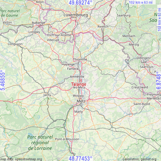
Talange GPS coordinates[2]
49° 14' 8.772" North, 6° 10' 18.012" East
| Map corner | latitude | longitude |
|---|---|---|
| Upper-left | 49.69274°, | 5.46855° |
| Center: | 49.23577°, | 6.17167° |
| Lower-right: | 48.77453°, | 6.8748° |
| Map W x H: | 102.1×102.1 km | = 63.4×63.4mi |
| max Lat: | 51.07786° ⇑15% North |
| Talange: | 49.23577° |
| min Lat: | ⇓85% South 41.3874° |
| min Long | Talange | max Long |
| -5.08615° | 6.17167° | 9.52242° |
| W 89%⇐ | ⇒11% E |
Elevation
Elevation of Talange is 158 m = 518 ft, and this is 35.7 m = 117 ft below average elevation for this country.
| Max E: |
2333 m = 7654 ft | 42.9% |
| Avg. | 193.7 m = 635 ft | |
| Talange | 158 m = 518 ft | |
Min E: |
-1 m = -3 ft | 57.1% |
See also: France elevation on elevation.city.
Geographical zone
Talange is located in North temperate zone (between Tropic of Cancer and the Arctic Circle). Distance of this North polar circle is 1926.7 km =1197.2 mi to North.| Distance of | km | miles | from Talange |
|---|---|---|---|
| North Pole | 4532.6 | 2816.4 | to North |
| Arctic Circle | 1926.7 | 1197.2 | to North |
| Tropic Cancer | 2868.6 | 1782.5 | to South |
| Equator | 5474.5 | 3401.7 | to South |


Nearby cities:
15 places around Talange: (largest is in red/bold)
• Amnéville
3.6 km =2.2 mi,  310°
310°
• Argancy
5 km =3.1 mi,  154°
154°
• Ay-sur-Moselle
2.6 km =1.6 mi,  71°
71°
• Bousse
5 km =3.1 mi,  21°
21°
• Ennery
3.5 km =2.2 mi,  107°
107°
• Flévy
5.3 km =3.3 mi,  87°
87°
• Gandrange
5.2 km =3.2 mi,  319°
319°
• Hagondange
1.6 km =1 mi,  338°
338°
• Hauconcourt
2.3 km =1.4 mi,  144°
144°
• Maizières-lès-Metz
2.6 km =1.6 mi,  199°
199°
• Mondelange
2.9 km =1.8 mi,  350°
350°
• Pierrevillers
5.1 km =3.2 mi,  256°
256°
• Richemont
4.6 km =2.9 mi, 352°
• Semécourt
5.2 km =3.2 mi,  208°
208°
• Trémery
3.9 km =2.4 mi, 73°
Sources, notices
• [Note1] Compared only with cities in France existing in our database
• [Src1] Map data: © OpenStreetMap contributors (CC-BY-SA)
• [Src2] Other city data from geonames.org with taken over terms of usage.
• [Src3] Geographical zone / Annual Mean Temperature by Robert A. Rohde @ Wikipedia
