Fameck geodata
Fameck (Grand Est) is a populated place; located in France in Europe/Paris (GMT+2) time zone. With population of 12,291 people, there are 782 cities with bigger population in this country. Compared to other cities in France, 86.1% of cities are located further ↓South; 88.3% of cities are located further ←West and 62.1% of cities have lower elevation than Fameck. Note1
Administrative division(s):
- Level 1: Grand Est
- Level 2: Moselle
- Level 3: Arrondissement de Thionville
- Level 4: Fameck


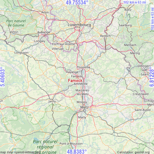
Fameck GPS coordinates[2]
49° 17' 56.22" North, 6° 6' 32.94" East
| Map corner | latitude | longitude |
|---|---|---|
| Upper-left | 49.75534°, | 5.40603° |
| Center: | 49.29895°, | 6.10915° |
| Lower-right: | 48.8383°, | 6.81228° |
| Map W x H: | 102×102 km | = 63.4×63.4mi |
| max Lat: | 51.07786° ⇑13.9% North |
| Fameck: | 49.29895° |
| min Lat: | ⇓86.1% South 41.3874° |
| min Long | Fameck | max Long |
| -5.08615° | 6.10915° | 9.52242° |
| W 88.3%⇐ | ⇒11.7% E |
Elevation
Elevation of Fameck is 180 m = 591 ft, and this is 13.7 m = 45 ft below average elevation for this country.
| Max E: |
2333 m = 7654 ft | 37.9% |
| Avg. | 193.7 m = 635 ft | |
| Fameck | 180 m = 591 ft | |
Min E: |
-1 m = -3 ft | 62.1% |
See also: France elevation on elevation.city.
Geographical zone
Fameck is located in North temperate zone (between Tropic of Cancer and the Arctic Circle). Distance of this North polar circle is 1919.6 km =1192.8 mi to North.| Distance of | km | miles | from Fameck |
|---|---|---|---|
| North Pole | 4525.5 | 2812 | to North |
| Arctic Circle | 1919.6 | 1192.8 | to North |
| Tropic Cancer | 2875.6 | 1786.8 | to South |
| Equator | 5481.5 | 3406 | to South |


Nearby cities:
15 places around Fameck: (largest is in red/bold)
• Amnéville
5 km =3.1 mi,  158°
158°
• Clouange
4.2 km =2.6 mi,  192°
192°
• Florange
2.9 km =1.8 mi,  17°
17°
• Gandrange
3.3 km =2.1 mi, 159°
• Hayange
4.7 km =2.9 mi,  314°
314°
• Illange
5.9 km =3.7 mi,  59°
59°
• Mondelange
5.8 km =3.6 mi,  135°
135°
• Ranguevaux
4 km =2.5 mi,  267°
267°
• Richemont
4.6 km =2.9 mi,  121°
121°
• Rombas
5.6 km =3.5 mi, 191°
• Rosselange
5.4 km =3.4 mi,  212°
212°
• Serémange-Erzange
2.7 km =1.7 mi,  331°
331°
• Terville
5.6 km =3.5 mi, 18°
• Uckange
2.9 km =1.8 mi,  81°
81°
• Vitry-sur-Orne
3.7 km =2.3 mi,  178°
178°
Sources, notices
• [Note1] Compared only with cities in France existing in our database
• [Src1] Map data: © OpenStreetMap contributors (CC-BY-SA)
• [Src2] Other city data from geonames.org with taken over terms of usage.
• [Src3] Geographical zone / Annual Mean Temperature by Robert A. Rohde @ Wikipedia
