Brignon geodata
Brignon (Occitanie) is a populated place; located in France in Europe/Paris (GMT+2) time zone. With population of 717 people, there are 11570 cities with bigger population in this country. Compared to other cities in France, 87.2% of cities are located further ↑North; 69.8% of cities are located further ←West and 62.8% of cities have higher elevation than Brignon. Note1
Administrative division(s):
- Level 1: Occitanie
- Level 2: Gard
- Level 3: Arrondissement d’Alès
- Level 4: Brignon


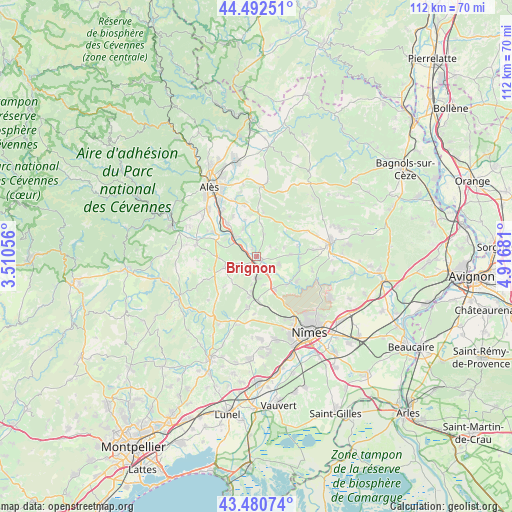
Brignon GPS coordinates[2]
43° 59' 19.608" North, 4° 12' 49.248" East
| Map corner | latitude | longitude |
|---|---|---|
| Upper-left | 44.49251°, | 3.51056° |
| Center: | 43.98878°, | 4.21368° |
| Lower-right: | 43.48074°, | 4.91681° |
| Map W x H: | 112.5×112.5 km | = 69.9×69.9mi |
| max Lat: | 51.07786° ⇑87.2% North |
| Brignon: | 43.98878° |
| min Lat: | ⇓12.8% South 41.3874° |
| min Long | Brignon | max Long |
| -5.08615° | 4.21368° | 9.52242° |
| W 69.8%⇐ | ⇒30.2% E |
Elevation
Elevation of Brignon is 95 m = 312 ft, and this is 98.7 m = 324 ft below average elevation for this country.
| Max E: |
2333 m = 7654 ft | 62.8% |
| Avg. | 193.7 m = 635 ft | |
| Brignon | 95 m = 312 ft | |
Min E: |
-1 m = -3 ft | 37.2% |
See also: France elevation on elevation.city.
Geographical zone
Brignon is located in North temperate zone (between Tropic of Cancer and the Arctic Circle). Distance of this Northern Tropic circle is 2285.2 km =1420 mi to South.| Distance of | km | miles | from Brignon |
|---|---|---|---|
| North Pole | 5116 | 3178.9 | to North |
| Arctic Circle | 2510.1 | 1559.7 | to North |
| Tropic Cancer | 2285.2 | 1420 | to South |
| Equator | 4891.1 | 3039.2 | to South |


Nearby cities:
15 places around Brignon: (largest is in red/bold)
• Boucoiran-et-Nozières
2.4 km =1.5 mi,  288°
288°
• Cruviers-Lascours
1.8 km =1.1 mi,  330°
330°
• Dions
9.2 km =5.7 mi,  133°
133°
• Domessargues
4.1 km =2.5 mi,  248°
248°
• Garrigues-Sainte-Eulalie
8.3 km =5.2 mi,  94°
94°
• La Calmette
8.5 km =5.3 mi,  150°
150°
• La Rouvière
6.6 km =4.1 mi,  165°
165°
• Lédignan
8.6 km =5.3 mi,  268°
268°
• Moussac
1.3 km =0.8 mi, 129°
• Ners
6 km =3.7 mi,  315°
315°
• Saint-Chaptes
5.5 km =3.4 mi,  110°
110°
• Saint-Geniès-de-Malgoirès
4.3 km =2.7 mi,  176°
176°
• Saint-Maurice-de-Cazevieille
4.8 km =3 mi,  19°
19°
• Sauzet
3.1 km =1.9 mi,  186°
186°
• Vézénobres
9.2 km =5.7 mi, 318°
Sources, notices
• [Note1] Compared only with cities in France existing in our database
• [Src1] Map data: © OpenStreetMap contributors (CC-BY-SA)
• [Src2] Other city data from geonames.org with taken over terms of usage.
• [Src3] Geographical zone / Annual Mean Temperature by Robert A. Rohde @ Wikipedia
