Gaël geodata
Gaël (Brittany) is a populated place; located in France in Europe/Paris (GMT+2) time zone. With population of 1,486 people, there are 6241 cities with bigger population in this country. Compared to other cities in France, 61.7% of cities are located further ↓South; 95.6% of cities are located further →East and 67.8% of cities have higher elevation than Gaël. Note1
Administrative division(s):
- Level 1: Brittany
- Level 2: Département d'Ille-et-Vilaine
- Level 3: Arrondissement de Rennes
- Level 4: Gaël


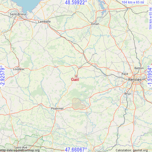
Gaël GPS coordinates[2]
48° 7' 55.524" North, 2° 13' 21.612" West
| Map corner | latitude | longitude |
|---|---|---|
| Upper-left | 48.59922°, | -2.92579° |
| Center: | 48.13209°, | -2.22267° |
| Lower-right: | 47.66067°, | -1.51954° |
| Map W x H: | 104.4×104.4 km | = 64.9×64.9mi |
| max Lat: | 51.07786° ⇑38.3% North |
| Gaël: | 48.13209° |
| min Lat: | ⇓61.7% South 41.3874° |
| min Long | Gaël | max Long |
| -5.08615° | -2.22267° | 9.52242° |
| W 4.4%⇐ | ⇒95.6% E |
Elevation
Elevation of Gaël is 83 m = 272 ft, and this is 110.7 m = 363 ft below average elevation for this country.
| Max E: |
2333 m = 7654 ft | 67.8% |
| Avg. | 193.7 m = 635 ft | |
| Gaël | 83 m = 272 ft | |
Min E: |
-1 m = -3 ft | 32.2% |
See also: France elevation on elevation.city.
Geographical zone
Gaël is located in North temperate zone (between Tropic of Cancer and the Arctic Circle). Distance of this North polar circle is 2049.4 km =1273.4 mi to North.| Distance of | km | miles | from Gaël |
|---|---|---|---|
| North Pole | 4655.3 | 2892.7 | to North |
| Arctic Circle | 2049.4 | 1273.4 | to North |
| Tropic Cancer | 2745.9 | 1706.2 | to South |
| Equator | 5351.8 | 3325.5 | to South |


Nearby cities:
15 places around Gaël: (largest is in red/bold)
• Boisgervilly
12.4 km =7.7 mi,  71°
71°
• Concoret
7.6 km =4.7 mi,  169°
169°
• Iffendic
13.9 km =8.6 mi,  91°
91°
• Illifaut
9.5 km =5.9 mi,  279°
279°
• Lanrelas
14.3 km =8.9 mi,  336°
336°
• Loscouët-sur-Meu
5.3 km =3.3 mi, 344°
• Mauron
7.2 km =4.5 mi,  219°
219°
• Montauban-de-Bretagne
15.2 km =9.4 mi,  60°
60°
• Muel
4.8 km =3 mi,  96°
96°
• Paimpont
13.2 km =8.2 mi,  163°
163°
• Plumaugat
13.7 km =8.5 mi,  355°
355°
• Quédillac
14.3 km =8.9 mi,  24°
24°
• Saint-Méen-le-Grand
6.7 km =4.2 mi, 17°
• Saint-Onen-la-Chapelle
6.2 km =3.9 mi,  36°
36°
• Trémorel
8.9 km =5.5 mi,  326°
326°
Sources, notices
• [Note1] Compared only with cities in France existing in our database
• [Src1] Map data: © OpenStreetMap contributors (CC-BY-SA)
• [Src2] Other city data from geonames.org with taken over terms of usage.
• [Src3] Geographical zone / Annual Mean Temperature by Robert A. Rohde @ Wikipedia
