Fresnay-sur-Sarthe geodata
Fresnay-sur-Sarthe (Pays de la Loire) is a populated place; located in France in Europe/Paris (GMT+2) time zone. With population of 2,443 people, there are 3966 cities with bigger population in this country. Compared to other cities in France, 64.2% of cities are located further ↓South; 78% of cities are located further →East and 62% of cities have higher elevation than Fresnay-sur-Sarthe. Note1
Administrative division(s):
- Level 1: Pays de la Loire
- Level 2: Sarthe
- Level 3: Arrondissement de Mamers
- Level 4: Fresnay-sur-Sarthe


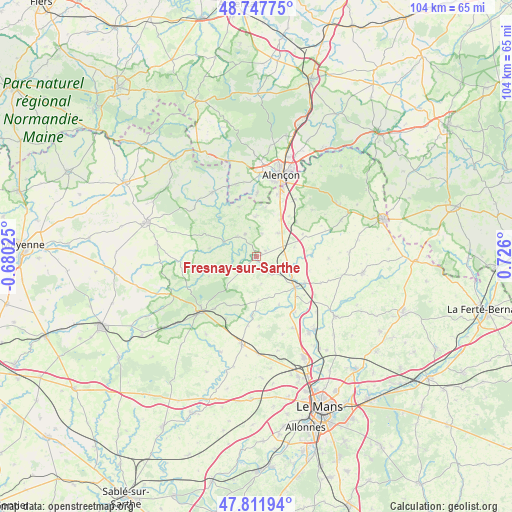
Fresnay-sur-Sarthe GPS coordinates[2]
48° 16' 55.164" North, 0° 1' 22.368" East
| Map corner | latitude | longitude |
|---|---|---|
| Upper-left | 48.74775°, | -0.68025° |
| Center: | 48.28199°, | 0.02288° |
| Lower-right: | 47.81194°, | 0.726° |
| Map W x H: | 104.1×104.1 km | = 64.7×64.7mi |
| max Lat: | 51.07786° ⇑35.8% North |
| Fresnay-sur-Sarthe: | 48.28199° |
| min Lat: | ⇓64.2% South 41.3874° |
| min Long | Fresnay-sur-Sar | max Long |
| -5.08615° | 0.02288° | 9.52242° |
| W 22%⇐ | ⇒78% E |
Elevation
Elevation of Fresnay-sur-Sarthe is 97 m = 318 ft, and this is 96.7 m = 317 ft below average elevation for this country.
| Max E: |
2333 m = 7654 ft | 62% |
| Avg. | 193.7 m = 635 ft | |
| Fresnay-sur-Sarthe | 97 m = 318 ft | |
Min E: |
-1 m = -3 ft | 38% |
See also: France elevation on elevation.city.
Geographical zone
Fresnay-sur-Sarthe is located in North temperate zone (between Tropic of Cancer and the Arctic Circle). Distance of this North polar circle is 2032.7 km =1263.1 mi to North.| Distance of | km | miles | from Fresnay-sur-Sarthe |
|---|---|---|---|
| North Pole | 4638.6 | 2882.3 | to North |
| Arctic Circle | 2032.7 | 1263.1 | to North |
| Tropic Cancer | 2762.5 | 1716.5 | to South |
| Equator | 5368.5 | 3335.8 | to South |


Nearby cities:
15 places around Fresnay-sur-Sarthe: (largest is in red/bold)
• Assé-le-Boisne
5 km =3.1 mi,  332°
332°
• Beaumont-sur-Sarthe
10.1 km =6.3 mi,  126°
126°
• Fyé
6.4 km =4 mi,  40°
40°
• Gesnes-le-Gandelin
8.1 km =5 mi,  357°
357°
• Maresché
12.4 km =7.7 mi, 128°
• Mont-Saint-Jean
10.7 km =6.6 mi,  246°
246°
• Moulins-le-Carbonnel
10.8 km =6.7 mi,  340°
340°
• Oisseau-le-Petit
8.7 km =5.4 mi,  32°
32°
• Saint-Aubin-de-Locquenay
1.4 km =0.9 mi,  176°
176°
• Saint-Georges-le-Gaultier
9.7 km =6 mi,  279°
279°
• Saint-Léonard-des-Bois
10.7 km =6.6 mi,  316°
316°
• Saint-Ouen-de-Mimbré
2.2 km =1.4 mi,  58°
58°
• Sougé-le-Ganelon
5.6 km =3.5 mi, 315°
• Ségrie
9.1 km =5.7 mi, 179°
• Vivoin
11.2 km =7 mi,  118°
118°
Sources, notices
• [Note1] Compared only with cities in France existing in our database
• [Src1] Map data: © OpenStreetMap contributors (CC-BY-SA)
• [Src2] Other city data from geonames.org with taken over terms of usage.
• [Src3] Geographical zone / Annual Mean Temperature by Robert A. Rohde @ Wikipedia
