Beaumont-sur-Sarthe geodata
Beaumont-sur-Sarthe (Pays de la Loire) is a populated place; located in France in Europe/Paris (GMT+2) time zone. With population of 2,080 people, there are 4626 cities with bigger population in this country. Compared to other cities in France, 63.3% of cities are located further ↓South; 76.9% of cities are located further →East and 70.5% of cities have higher elevation than Beaumont-sur-Sarthe. Note1
Administrative division(s):
- Level 1: Pays de la Loire
- Level 2: Sarthe
- Level 3: Arrondissement de Mamers
- Level 4: Beaumont-sur-Sarthe


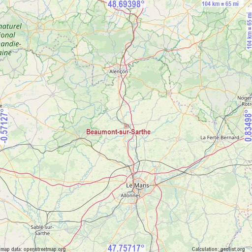
Beaumont-sur-Sarthe GPS coordinates[2]
48° 13' 39.792" North, 0° 7' 54.696" East
| Map corner | latitude | longitude |
|---|---|---|
| Upper-left | 48.69398°, | -0.57127° |
| Center: | 48.22772°, | 0.13186° |
| Lower-right: | 47.75717°, | 0.83498° |
| Map W x H: | 104.2×104.2 km | = 64.7×64.7mi |
| max Lat: | 51.07786° ⇑36.7% North |
| Beaumont-sur-Sarthe: | 48.22772° |
| min Lat: | ⇓63.3% South 41.3874° |
| min Long | Beaumont-sur-Sa | max Long |
| -5.08615° | 0.13186° | 9.52242° |
| W 23.1%⇐ | ⇒76.9% E |
Elevation
Elevation of Beaumont-sur-Sarthe is 77 m = 253 ft, and this is 116.7 m = 383 ft below average elevation for this country.
| Max E: |
2333 m = 7654 ft | 70.5% |
| Avg. | 193.7 m = 635 ft | |
| Beaumont-sur-Sarthe | 77 m = 253 ft | |
Min E: |
-1 m = -3 ft | 29.5% |
See also: France elevation on elevation.city.
Geographical zone
Beaumont-sur-Sarthe is located in North temperate zone (between Tropic of Cancer and the Arctic Circle). Distance of this North polar circle is 2038.8 km =1266.9 mi to North.| Distance of | km | miles | from Beaumont-sur-Sarthe |
|---|---|---|---|
| North Pole | 4644.6 | 2886 | to North |
| Arctic Circle | 2038.8 | 1266.9 | to North |
| Tropic Cancer | 2756.5 | 1712.8 | to South |
| Equator | 5362.4 | 3332 | to South |


Nearby cities:
15 places around Beaumont-sur-Sarthe: (largest is in red/bold)
• Ballon
9.9 km =6.2 mi,  127°
127°
• Courgains
12.9 km =8 mi,  57°
57°
• Dangeul
9.6 km =6 mi,  77°
77°
• Fresnay-sur-Sarthe
10.1 km =6.3 mi,  306°
306°
• Fyé
11.6 km =7.2 mi,  340°
340°
• Maresché
2.3 km =1.4 mi,  138°
138°
• Montbizot
9.5 km =5.9 mi,  155°
155°
• Saint-Aubin-de-Locquenay
9.2 km =5.7 mi,  300°
300°
• Saint-Mars-sous-Ballon
10.5 km =6.5 mi, 125°
• Saint-Ouen-de-Mimbré
9.5 km =5.9 mi,  319°
319°
• Sainte-Jamme-sur-Sarthe
9.8 km =6.1 mi, 164°
• Sainte-Sabine-sur-Longève
10 km =6.2 mi,  195°
195°
• Souligné-sous-Ballon
12.6 km =7.8 mi, 142°
• Ségrie
8.5 km =5.3 mi,  248°
248°
• Vivoin
1.9 km =1.2 mi,  69°
69°
Sources, notices
• [Note1] Compared only with cities in France existing in our database
• [Src1] Map data: © OpenStreetMap contributors (CC-BY-SA)
• [Src2] Other city data from geonames.org with taken over terms of usage.
• [Src3] Geographical zone / Annual Mean Temperature by Robert A. Rohde @ Wikipedia
