Gesnes-le-Gandelin geodata
Gesnes-le-Gandelin (Pays de la Loire) is a populated place; located in France in Europe/Paris (GMT+2) time zone. With population of 778 people, there are 10845 cities with bigger population in this country. Compared to other cities in France, 65.5% of cities are located further ↓South; 78% of cities are located further →East and 60% of cities have lower elevation than Gesnes-le-Gandelin. Note1
Administrative division(s):
- Level 1: Pays de la Loire
- Level 2: Sarthe
- Level 3: Arrondissement de Mamers
- Level 4: Gesnes-le-Gandelin


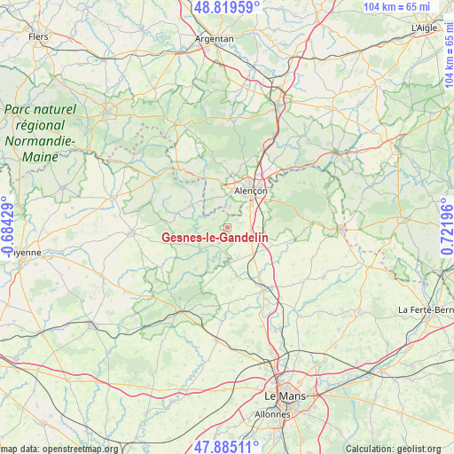
Gesnes-le-Gandelin GPS coordinates[2]
48° 21' 16.164" North, 0° 1' 7.824" East
| Map corner | latitude | longitude |
|---|---|---|
| Upper-left | 48.81959°, | -0.68429° |
| Center: | 48.35449°, | 0.01884° |
| Lower-right: | 47.88511°, | 0.72196° |
| Map W x H: | 103.9×103.9 km | = 64.6×64.6mi |
| max Lat: | 51.07786° ⇑34.5% North |
| Gesnes-le-Gandelin: | 48.35449° |
| min Lat: | ⇓65.5% South 41.3874° |
| min Long | Gesnes-le-Gande | max Long |
| -5.08615° | 0.01884° | 9.52242° |
| W 22%⇐ | ⇒78% E |
Elevation
Elevation of Gesnes-le-Gandelin is 170 m = 558 ft, and this is 23.7 m = 78 ft below average elevation for this country.
| Max E: |
2333 m = 7654 ft | 40% |
| Avg. | 193.7 m = 635 ft | |
| Gesnes-le-Gandelin | 170 m = 558 ft | |
Min E: |
-1 m = -3 ft | 60% |
See also: France elevation on elevation.city.
Geographical zone
Gesnes-le-Gandelin is located in North temperate zone (between Tropic of Cancer and the Arctic Circle). Distance of this North polar circle is 2024.7 km =1258.1 mi to North.| Distance of | km | miles | from Gesnes-le-Gandelin |
|---|---|---|---|
| North Pole | 4630.5 | 2877.3 | to North |
| Arctic Circle | 2024.7 | 1258.1 | to North |
| Tropic Cancer | 2770.6 | 1721.6 | to South |
| Equator | 5376.5 | 3340.8 | to South |


Nearby cities:
15 places around Gesnes-le-Gandelin: (largest is in red/bold)
• Arçonnay
6.8 km =4.2 mi,  46°
46°
• Assé-le-Boisne
4.2 km =2.6 mi,  209°
209°
• Champfleur
8.9 km =5.5 mi,  66°
66°
• Condé-sur-Sarthe
8.7 km =5.4 mi,  7°
7°
• Fresnay-sur-Sarthe
8.1 km =5 mi,  177°
177°
• Fyé
5.5 km =3.4 mi,  125°
125°
• Héloup
4.8 km =3 mi, 6°
• La Ferrière-Bochard
7.6 km =4.7 mi,  328°
328°
• Mieuxcé
5.1 km =3.2 mi,  354°
354°
• Moulins-le-Carbonnel
3.9 km =2.4 mi,  303°
303°
• Oisseau-le-Petit
5 km =3.1 mi,  98°
98°
• Saint-Germain-du-Corbéis
8.2 km =5.1 mi,  22°
22°
• Saint-Léonard-des-Bois
7.1 km =4.4 mi,  267°
267°
• Saint-Ouen-de-Mimbré
7.2 km =4.5 mi,  162°
162°
• Sougé-le-Ganelon
5.5 km =3.4 mi,  221°
221°
Sources, notices
• [Note1] Compared only with cities in France existing in our database
• [Src1] Map data: © OpenStreetMap contributors (CC-BY-SA)
• [Src2] Other city data from geonames.org with taken over terms of usage.
• [Src3] Geographical zone / Annual Mean Temperature by Robert A. Rohde @ Wikipedia
