Fortschwihr geodata
Fortschwihr (Grand Est) is a populated place; located in France in Europe/Paris (GMT+2) time zone. With population of 1,015 people, there are 8732 cities with bigger population in this country. Compared to other cities in France, 61% of cities are located further ↓South; 97.6% of cities are located further ←West and 63.3% of cities have lower elevation than Fortschwihr. Note1
Administrative division(s):
- Level 1: Grand Est
- Level 2: Haut-Rhin
- Level 3: Arrondissement de Colmar-Ribeauvillé
- Level 4: Fortschwihr


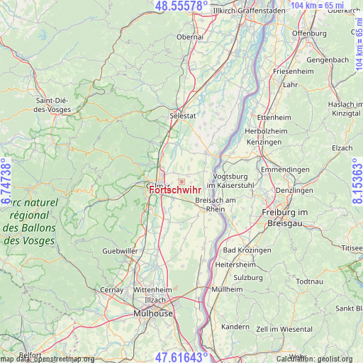
Fortschwihr GPS coordinates[2]
48° 5' 17.7" North, 7° 27' 1.8" East
| Map corner | latitude | longitude |
|---|---|---|
| Upper-left | 48.55578°, | 6.74738° |
| Center: | 48.08825°, | 7.4505° |
| Lower-right: | 47.61643°, | 8.15363° |
| Map W x H: | 104.4×104.4 km | = 64.9×64.9mi |
| max Lat: | 51.07786° ⇑39% North |
| Fortschwihr: | 48.08825° |
| min Lat: | ⇓61% South 41.3874° |
| min Long | Fortschwihr | max Long |
| -5.08615° | 7.4505° | 9.52242° |
| W 97.6%⇐ | ⇒2.4% E |
Elevation
Elevation of Fortschwihr is 186 m = 610 ft, and this is 7.7 m = 25 ft below average elevation for this country.
| Max E: |
2333 m = 7654 ft | 36.7% |
| Avg. | 193.7 m = 635 ft | |
| Fortschwihr | 186 m = 610 ft | |
Min E: |
-1 m = -3 ft | 63.3% |
See also: France elevation on elevation.city.
Geographical zone
Fortschwihr is located in North temperate zone (between Tropic of Cancer and the Arctic Circle). Distance of this North polar circle is 2054.3 km =1276.5 mi to North.| Distance of | km | miles | from Fortschwihr |
|---|---|---|---|
| North Pole | 4660.1 | 2895.7 | to North |
| Arctic Circle | 2054.3 | 1276.5 | to North |
| Tropic Cancer | 2741 | 1703.2 | to South |
| Equator | 5346.9 | 3322.4 | to South |


Nearby cities:
15 places around Fortschwihr: (largest is in red/bold)
• Andolsheim
3.9 km =2.4 mi,  220°
220°
• Bischwihr
1.4 km =0.9 mi,  314°
314°
• Colmar
7.1 km =4.4 mi,  263°
263°
• Durrenentzen
3.8 km =2.4 mi,  81°
81°
• Grussenheim
7 km =4.3 mi,  23°
23°
• Holtzwihr
3.5 km =2.2 mi,  321°
321°
• Horbourg-Wihr
4.3 km =2.7 mi, 259°
• Houssen
6.8 km =4.2 mi, 307°
• Jebsheim
4.4 km =2.7 mi,  25°
25°
• Kunheim
6.4 km =4 mi,  101°
101°
• Muntzenheim
2.4 km =1.5 mi,  52°
52°
• Sundhoffen
5.8 km =3.6 mi,  208°
208°
• Urschenheim
2.5 km =1.6 mi,  93°
93°
• Wickerschwihr
2.5 km =1.6 mi,  332°
332°
• Widensolen
3.5 km =2.2 mi,  141°
141°
Sources, notices
• [Note1] Compared only with cities in France existing in our database
• [Src1] Map data: © OpenStreetMap contributors (CC-BY-SA)
• [Src2] Other city data from geonames.org with taken over terms of usage.
• [Src3] Geographical zone / Annual Mean Temperature by Robert A. Rohde @ Wikipedia
