Colmar geodata
Colmar (Grand Est) is a seat of a second-order administrative division; located in France in Europe/Paris (GMT+2) time zone. With population of 65,405 people, there are 71 cities with bigger population in this country. Compared to other cities in France, 60.8% of cities are located further ↓South; 97% of cities are located further ←West and 64.2% of cities have lower elevation than Colmar. Note1
Administrative division(s):
- Level 1: Grand Est
- Level 2: Haut-Rhin
- Level 3: Arrondissement de Colmar-Ribeauvillé
- Level 4: Colmar


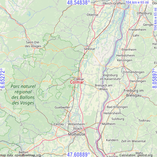
Colmar GPS coordinates[2]
48° 4' 50.808" North, 7° 21' 21.024" East
| Map corner | latitude | longitude |
|---|---|---|
| Upper-left | 48.54838°, | 6.65272° |
| Center: | 48.08078°, | 7.35584° |
| Lower-right: | 47.60889°, | 8.05897° |
| Map W x H: | 104.5×104.5 km | = 64.9×64.9mi |
| max Lat: | 51.07786° ⇑39.2% North |
| Colmar: | 48.08078° |
| min Lat: | ⇓60.8% South 41.3874° |
| min Long | Colmar | max Long |
| -5.08615° | 7.35584° | 9.52242° |
| W 97%⇐ | ⇒3% E |
Elevation
Elevation of Colmar is 190 m = 623 ft, and this is 3.7 m = 12 ft below average elevation for this country.
| Max E: |
2333 m = 7654 ft | 35.8% |
| Avg. | 193.7 m = 635 ft | |
| Colmar | 190 m = 623 ft | |
Min E: |
-1 m = -3 ft | 64.2% |
See also: Colmar elevation on elevation.city.
Geographical zone
Colmar is located in North temperate zone (between Tropic of Cancer and the Arctic Circle). Distance of this North polar circle is 2055.1 km =1277 mi to North.| Distance of | km | miles | from Colmar |
|---|---|---|---|
| North Pole | 4661 | 2896.2 | to North |
| Arctic Circle | 2055.1 | 1277 | to North |
| Tropic Cancer | 2740.2 | 1702.7 | to South |
| Equator | 5346.1 | 3321.9 | to South |


Nearby cities:
15 places around Colmar: (largest is in red/bold)
• Andolsheim
5 km =3.1 mi,  115°
115°
• Bischwihr
6.3 km =3.9 mi,  73°
73°
• Eguisheim
5.6 km =3.5 mi,  221°
221°
• Fortschwihr
7.1 km =4.4 mi,  83°
83°
• Holtzwihr
6 km =3.7 mi,  53°
53°
• Horbourg-Wihr
2.8 km =1.7 mi,  89°
89°
• Houssen
5.3 km =3.3 mi,  17°
17°
• Ingersheim
4.4 km =2.7 mi,  296°
296°
• Katzenthal
6.3 km =3.9 mi, 298°
• Niedermorschwihr
6.5 km =4 mi,  289°
289°
• Sundhoffen
6 km =3.7 mi,  134°
134°
• Turckheim
5.9 km =3.7 mi,  277°
277°
• Wettolsheim
5 km =3.1 mi,  238°
238°
• Wickerschwihr
6.6 km =4.1 mi,  62°
62°
• Wintzenheim
4.9 km =3 mi,  259°
259°
Sources, notices
• [Note1] Compared only with cities in France existing in our database
• [Src1] Map data: © OpenStreetMap contributors (CC-BY-SA)
• [Src2] Other city data from geonames.org with taken over terms of usage.
• [Src3] Geographical zone / Annual Mean Temperature by Robert A. Rohde @ Wikipedia
