Forcalquier geodata
Forcalquier (Provence-Alpes-Côte d'Azur) is a seat of a third-order administrative division; located in France in Europe/Paris (GMT+2) time zone. With population of 4,729 people, there are 2095 cities with bigger population in this country. Compared to other cities in France, 87.4% of cities are located further ↑North; 84.9% of cities are located further ←West and 93.7% of cities have lower elevation than Forcalquier. Note1
Administrative division(s):
- Level 1: Provence-Alpes-Côte d'Azur
- Level 2: Alpes-de-Haute-Provence
- Level 3: Arrondissement de Forcalquier
- Level 4: Forcalquier


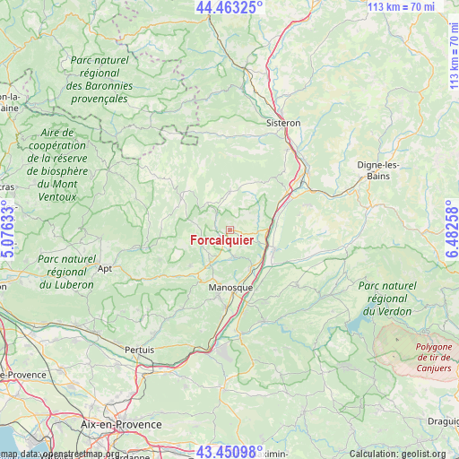
Forcalquier GPS coordinates[2]
43° 57' 33.372" North, 5° 46' 46.02" East
| Map corner | latitude | longitude |
|---|---|---|
| Upper-left | 44.46325°, | 5.07633° |
| Center: | 43.95927°, | 5.77945° |
| Lower-right: | 43.45098°, | 6.48258° |
| Map W x H: | 112.6×112.6 km | = 70×70mi |
| max Lat: | 51.07786° ⇑87.4% North |
| Forcalquier: | 43.95927° |
| min Lat: | ⇓12.6% South 41.3874° |
| min Long | Forcalquier | max Long |
| -5.08615° | 5.77945° | 9.52242° |
| W 84.9%⇐ | ⇒15.1% E |
Elevation
Elevation of Forcalquier is 530 m = 1739 ft, and this is 336.3 m = 1103 ft above average elevation for this country.
| Max E: |
2333 m = 7654 ft | 6.3% |
| Forcalquier | 530 m 1739 ft | |
| Avg. | 193.7 m = 635 ft | |
Min E: |
-1 m = -3 ft | 93.7% |
See also: France elevation on elevation.city.
Geographical zone
Forcalquier is located in North temperate zone (between Tropic of Cancer and the Arctic Circle). Distance of this Northern Tropic circle is 2281.9 km =1417.9 mi to South.| Distance of | km | miles | from Forcalquier |
|---|---|---|---|
| North Pole | 5119.2 | 3180.9 | to North |
| Arctic Circle | 2513.4 | 1561.8 | to North |
| Tropic Cancer | 2281.9 | 1417.9 | to South |
| Equator | 4887.8 | 3037.1 | to South |


Nearby cities:
15 places around Forcalquier: (largest is in red/bold)
• Banon
14.9 km =9.3 mi,  305°
305°
• Cruis
12.3 km =7.6 mi,  21°
21°
• Dauphin
6.8 km =4.2 mi,  178°
178°
• La Brillanne
9.6 km =6 mi,  111°
111°
• Mane
2.6 km =1.6 mi,  202°
202°
• Manosque
14.5 km =9 mi, 177°
• Oraison
12.1 km =7.5 mi, 112°
• Peyruis
15 km =9.3 mi,  59°
59°
• Pierrerue
4.3 km =2.7 mi,  94°
94°
• Reillanne
13.1 km =8.1 mi,  227°
227°
• Saint-Maime
6.2 km =3.9 mi,  170°
170°
• Saint-Michel-l’Observatoire
7.5 km =4.7 mi,  222°
222°
• Saint-Étienne-les-Orgues
9.6 km =6 mi,  0°
0°
• Villeneuve
9.8 km =6.1 mi,  137°
137°
• Volx
10.3 km =6.4 mi,  151°
151°
Sources, notices
• [Note1] Compared only with cities in France existing in our database
• [Src1] Map data: © OpenStreetMap contributors (CC-BY-SA)
• [Src2] Other city data from geonames.org with taken over terms of usage.
• [Src3] Geographical zone / Annual Mean Temperature by Robert A. Rohde @ Wikipedia
