Banon geodata
Banon (Provence-Alpes-Côte d'Azur) is a populated place; located in France in Europe/Paris (GMT+2) time zone. With population of 941 people, there are 9290 cities with bigger population in this country. Compared to other cities in France, 86.8% of cities are located further ↑North; 83.9% of cities are located further ←West and 97.7% of cities have lower elevation than Banon. Note1
Administrative division(s):
- Level 1: Provence-Alpes-Côte d'Azur
- Level 2: Alpes-de-Haute-Provence
- Level 3: Arrondissement de Forcalquier
- Level 4: Banon


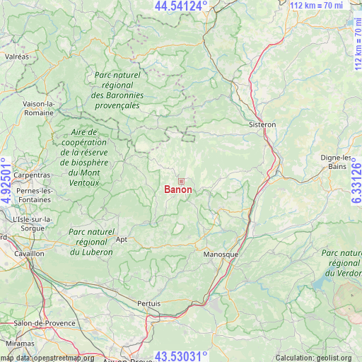
Banon GPS coordinates[2]
44° 2' 16.548" North, 5° 37' 41.268" East
| Map corner | latitude | longitude |
|---|---|---|
| Upper-left | 44.54124°, | 4.92501° |
| Center: | 44.03793°, | 5.62813° |
| Lower-right: | 43.53031°, | 6.33126° |
| Map W x H: | 112.4×112.4 km | = 69.8×69.8mi |
| max Lat: | 51.07786° ⇑86.8% North |
| Banon: | 44.03793° |
| min Lat: | ⇓13.2% South 41.3874° |
| min Long | Banon | max Long |
| -5.08615° | 5.62813° | 9.52242° |
| W 83.9%⇐ | ⇒16.1% E |
Elevation
Elevation of Banon is 795 m = 2608 ft, and this is 601.3 m = 1973 ft above average elevation for this country.
| Max E: |
2333 m = 7654 ft | 2.3% |
| Banon | 795 m 2608 ft | |
| Avg. | 193.7 m = 635 ft | |
Min E: |
-1 m = -3 ft | 97.7% |
See also: France elevation on elevation.city.
Geographical zone
Banon is located in North temperate zone (between Tropic of Cancer and the Arctic Circle). Distance of this Northern Tropic circle is 2290.6 km =1423.3 mi to South.| Distance of | km | miles | from Banon |
|---|---|---|---|
| North Pole | 5110.5 | 3175.5 | to North |
| Arctic Circle | 2504.6 | 1556.3 | to North |
| Tropic Cancer | 2290.6 | 1423.3 | to South |
| Equator | 4896.6 | 3042.6 | to South |


Nearby cities:
15 places around Banon: (largest is in red/bold)
• Cruis
16.8 km =10.4 mi,  80°
80°
• Dauphin
19.9 km =12.4 mi,  141°
141°
• Forcalquier
14.9 km =9.3 mi,  125°
125°
• Mane
15.7 km =9.8 mi, 134°
• Pierrerue
18.7 km =11.6 mi,  119°
119°
• Reillanne
17.8 km =11.1 mi,  171°
171°
• Revest-du-Bion
8.1 km =5 mi,  308°
308°
• Rustrel
17 km =10.6 mi,  222°
222°
• Saint-Christol
10.9 km =6.8 mi,  264°
264°
• Saint-Maime
19.9 km =12.4 mi, 138°
• Saint-Michel-l’Observatoire
15.9 km =9.9 mi,  153°
153°
• Saint-Étienne-les-Orgues
12.2 km =7.6 mi,  86°
86°
• Sault
18.5 km =11.5 mi,  288°
288°
• Simiane-la-Rotonde
8.2 km =5.1 mi, 219°
• Viens
16.7 km =10.4 mi,  197°
197°
Sources, notices
• [Note1] Compared only with cities in France existing in our database
• [Src1] Map data: © OpenStreetMap contributors (CC-BY-SA)
• [Src2] Other city data from geonames.org with taken over terms of usage.
• [Src3] Geographical zone / Annual Mean Temperature by Robert A. Rohde @ Wikipedia
