Fleury-la-Vallée geodata
Fleury-la-Vallée (Bourgogne-Franche-Comté) is a populated place; located in France in Europe/Paris (GMT+2) time zone. With population of 1,053 people, there are 8446 cities with bigger population in this country. Compared to other cities in France, 56.9% of cities are located further ↓South; 63.7% of cities are located further ←West and 51.4% of cities have lower elevation than Fleury-la-Vallée. Note1
Administrative division(s):
- Level 1: Bourgogne-Franche-Comté
- Level 2: Département de l'Yonne
- Level 3: Auxerre
- Level 4: Fleury-la-Vallée


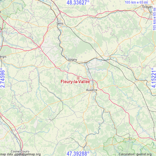
Fleury-la-Vallée GPS coordinates[2]
47° 52' 0.192" North, 3° 26' 56.688" East
| Map corner | latitude | longitude |
|---|---|---|
| Upper-left | 48.33627°, | 2.74596° |
| Center: | 47.86672°, | 3.44908° |
| Lower-right: | 47.39288°, | 4.15221° |
| Map W x H: | 104.9×104.9 km | = 65.2×65.2mi |
| max Lat: | 51.07786° ⇑43.1% North |
| Fleury-la-Vallée: | 47.86672° |
| min Lat: | ⇓56.9% South 41.3874° |
| min Long | Fleury-la-Vall� | max Long |
| -5.08615° | 3.44908° | 9.52242° |
| W 63.7%⇐ | ⇒36.3% E |
Elevation
Elevation of Fleury-la-Vallée is 137 m = 449 ft, and this is 56.7 m = 186 ft below average elevation for this country.
| Max E: |
2333 m = 7654 ft | 48.6% |
| Avg. | 193.7 m = 635 ft | |
| Fleury-la-Vallée | 137 m = 449 ft | |
Min E: |
-1 m = -3 ft | 51.4% |
See also: France elevation on elevation.city.
Geographical zone
Fleury-la-Vallée is located in North temperate zone (between Tropic of Cancer and the Arctic Circle). Distance of this North polar circle is 2078.9 km =1291.8 mi to North.| Distance of | km | miles | from Fleury-la-Vallée |
|---|---|---|---|
| North Pole | 4684.8 | 2911 | to North |
| Arctic Circle | 2078.9 | 1291.8 | to North |
| Tropic Cancer | 2716.4 | 1687.9 | to South |
| Equator | 5322.3 | 3307.1 | to South |


Nearby cities:
15 places around Fleury-la-Vallée: (largest is in red/bold)
• Aillant-sur-Tholon
7.4 km =4.6 mi,  276°
276°
• Appoigny
5.7 km =3.5 mi,  81°
81°
• Bassou
8 km =5 mi,  37°
37°
• Bonnard
8.6 km =5.3 mi, 41°
• Champlay
9.4 km =5.8 mi,  355°
355°
• Charbuy
5 km =3.1 mi,  165°
165°
• Chemilly-sur-Yonne
9.1 km =5.7 mi,  67°
67°
• Guerchy
2.8 km =1.7 mi,  344°
344°
• Gurgy
8.5 km =5.3 mi,  89°
89°
• Lindry
7.7 km =4.8 mi,  197°
197°
• Monéteau
10.1 km =6.3 mi,  101°
101°
• Poilly-sur-Tholon
4.1 km =2.5 mi,  267°
267°
• Saint-Georges-sur-Baulche
9.6 km =6 mi,  140°
140°
• Senan
8.4 km =5.2 mi,  307°
307°
• Épineau-les-Voves
9.6 km =6 mi,  14°
14°
Sources, notices
• [Note1] Compared only with cities in France existing in our database
• [Src1] Map data: © OpenStreetMap contributors (CC-BY-SA)
• [Src2] Other city data from geonames.org with taken over terms of usage.
• [Src3] Geographical zone / Annual Mean Temperature by Robert A. Rohde @ Wikipedia
