Capdenac-Gare geodata
Capdenac-Gare (Occitanie) is a populated place; located in France in Europe/Paris (GMT+2) time zone. With population of 1,075 people, there are 8295 cities with bigger population in this country. Compared to other cities in France, 83% of cities are located further ↑North; 56% of cities are located further →East and 61.5% of cities have lower elevation than Capdenac-Gare. Note1
Administrative division(s):
- Level 1: Occitanie
- Level 2: Département de l'Aveyron
- Level 3: Arrondissement de Villefranche-de-Rouergue
- Level 4: Capdenac-Gare


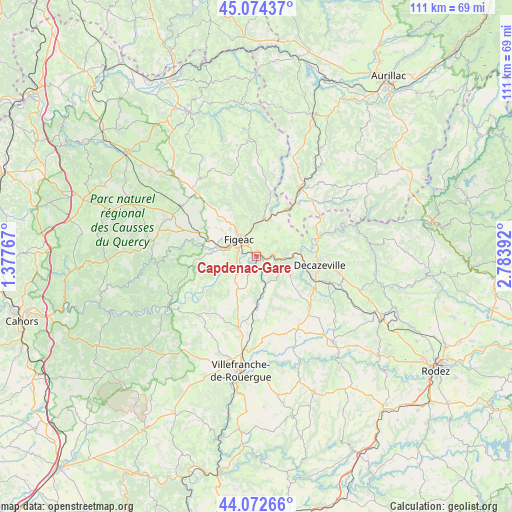
Capdenac-Gare GPS coordinates[2]
44° 34' 32.412" North, 2° 4' 50.844" East
| Map corner | latitude | longitude |
|---|---|---|
| Upper-left | 45.07437°, | 1.37767° |
| Center: | 44.57567°, | 2.08079° |
| Lower-right: | 44.07266°, | 2.78392° |
| Map W x H: | 111.4×111.4 km | = 69.2×69.2mi |
| max Lat: | 51.07786° ⇑83% North |
| Capdenac-Gare: | 44.57567° |
| min Lat: | ⇓17% South 41.3874° |
| min Long | Capdenac-Gare | max Long |
| -5.08615° | 2.08079° | 9.52242° |
| W 44%⇐ | ⇒56% E |
Elevation
Elevation of Capdenac-Gare is 177 m = 581 ft, and this is 16.7 m = 55 ft below average elevation for this country.
| Max E: |
2333 m = 7654 ft | 38.5% |
| Avg. | 193.7 m = 635 ft | |
| Capdenac-Gare | 177 m = 581 ft | |
Min E: |
-1 m = -3 ft | 61.5% |
See also: France elevation on elevation.city.
Geographical zone
Capdenac-Gare is located in North temperate zone (between Tropic of Cancer and the Arctic Circle). Distance of this Northern Tropic circle is 2350.4 km =1460.5 mi to South.| Distance of | km | miles | from Capdenac-Gare |
|---|---|---|---|
| North Pole | 5050.7 | 3138.4 | to North |
| Arctic Circle | 2444.8 | 1519.1 | to North |
| Tropic Cancer | 2350.4 | 1460.5 | to South |
| Equator | 4956.3 | 3079.7 | to South |


Nearby cities:
15 places around Capdenac-Gare: (largest is in red/bold)
• Aubin
14 km =8.7 mi,  112°
112°
• Bagnac-sur-Célé
12.2 km =7.6 mi,  33°
33°
• Boisse-Penchot
10.2 km =6.3 mi,  79°
79°
• Béduer
10.6 km =6.6 mi,  273°
273°
• Cardaillac
13.2 km =8.2 mi,  330°
330°
• Decazeville
13.6 km =8.5 mi,  97°
97°
• Faycelles
7.5 km =4.7 mi,  261°
261°
• Figeac
5.3 km =3.3 mi,  313°
313°
• Flagnac
13.6 km =8.5 mi, 76°
• Livinhac-le-Haut
12 km =7.5 mi, 81°
• Montbazens
16 km =9.9 mi,  132°
132°
• Saint-Constant
17 km =10.6 mi,  44°
44°
• Saint-Santin
13.6 km =8.5 mi,  52°
52°
• Villeneuve
16.3 km =10.1 mi,  193°
193°
• Viviez
11 km =6.8 mi, 101°
Sources, notices
• [Note1] Compared only with cities in France existing in our database
• [Src1] Map data: © OpenStreetMap contributors (CC-BY-SA)
• [Src2] Other city data from geonames.org with taken over terms of usage.
• [Src3] Geographical zone / Annual Mean Temperature by Robert A. Rohde @ Wikipedia
