Fitou geodata
Fitou (Occitanie) is a populated place; located in France in Europe/Paris (GMT+2) time zone. With population of 715 people, there are 11591 cities with bigger population in this country. Compared to other cities in France, 98.6% of cities are located further ↑North; 57.5% of cities are located further ←West and 74.1% of cities have higher elevation than Fitou. Note1
Administrative division(s):
- Level 1: Occitanie
- Level 2: Département de l'Aude
- Level 3: Arrondissement de Narbonne
- Level 4: Fitou


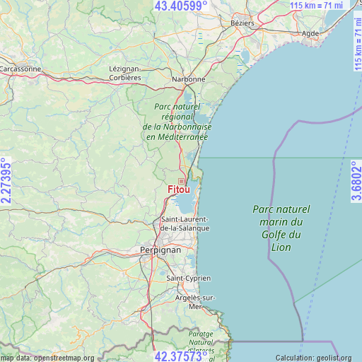
Fitou GPS coordinates[2]
42° 53' 34.836" North, 2° 58' 37.488" East
| Map corner | latitude | longitude |
|---|---|---|
| Upper-left | 43.40599°, | 2.27395° |
| Center: | 42.89301°, | 2.97708° |
| Lower-right: | 42.37573°, | 3.6802° |
| Map W x H: | 114.6×114.6 km | = 71.2×71.2mi |
| max Lat: | 51.07786° ⇑98.6% North |
| Fitou: | 42.89301° |
| min Lat: | ⇓1.4% South 41.3874° |
| min Long | Fitou | max Long |
| -5.08615° | 2.97708° | 9.52242° |
| W 57.5%⇐ | ⇒42.5% E |
Elevation
Elevation of Fitou is 69 m = 226 ft, and this is 124.7 m = 409 ft below average elevation for this country.
| Max E: |
2333 m = 7654 ft | 74.1% |
| Avg. | 193.7 m = 635 ft | |
| Fitou | 69 m = 226 ft | |
Min E: |
-1 m = -3 ft | 25.9% |
See also: France elevation on elevation.city.
Geographical zone
Fitou is located in North temperate zone (between Tropic of Cancer and the Arctic Circle). Distance of this Northern Tropic circle is 2163.3 km =1344.2 mi to South.| Distance of | km | miles | from Fitou |
|---|---|---|---|
| North Pole | 5237.8 | 3254.6 | to North |
| Arctic Circle | 2631.9 | 1635.4 | to North |
| Tropic Cancer | 2163.3 | 1344.2 | to South |
| Equator | 4769.3 | 2963.5 | to South |


Nearby cities:
15 places around Fitou: (largest is in red/bold)
• Caves
4.2 km =2.6 mi,  359°
359°
• Claira
14.9 km =9.3 mi,  186°
186°
• La Palme
9.2 km =5.7 mi,  7°
7°
• Le Barcarès
12.7 km =7.9 mi,  157°
157°
• Leucate
4.7 km =2.9 mi,  65°
65°
• Opoul-Périllos
8.2 km =5.1 mi,  249°
249°
• Port-la-Nouvelle
15.1 km =9.4 mi,  21°
21°
• Rivesaltes
16.2 km =10.1 mi,  211°
211°
• Roquefort-des-Corbières
11.1 km =6.9 mi,  350°
350°
• Saint-Hippolyte
12 km =7.5 mi,  184°
184°
• Saint-Laurent-de-la-Salanque
13.4 km =8.3 mi, 175°
• Salses-le-Château
8.3 km =5.2 mi,  216°
216°
• Sigean
15 km =9.3 mi,  0°
0°
• Torreilles
15.5 km =9.6 mi, 175°
• Vingrau
17 km =10.6 mi, 252°
Sources, notices
• [Note1] Compared only with cities in France existing in our database
• [Src1] Map data: © OpenStreetMap contributors (CC-BY-SA)
• [Src2] Other city data from geonames.org with taken over terms of usage.
• [Src3] Geographical zone / Annual Mean Temperature by Robert A. Rohde @ Wikipedia
