Salses-le-Château geodata
Salses-le-Château (Occitanie) is a populated place; located in France in Europe/Paris (GMT+2) time zone. With population of 2,740 people, there are 3578 cities with bigger population in this country. Compared to other cities in France, 98.7% of cities are located further ↑North; 56.6% of cities are located further ←West and 96.3% of cities have higher elevation than Salses-le-Château. Note1
Administrative division(s):
- Level 1: Occitanie
- Level 2: Département des Pyrénées-Orientales
- Level 3: Arrondissement de Perpignan
- Level 4: Salses-le-Château


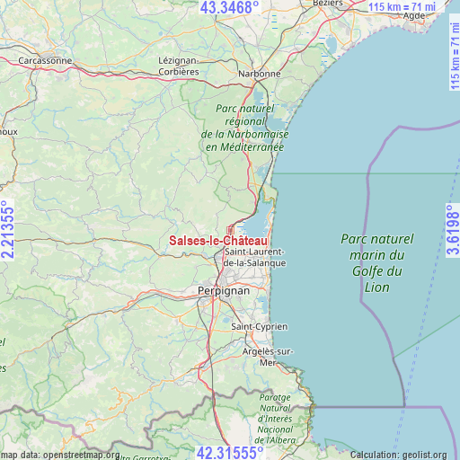
Salses-le-Château GPS coordinates[2]
42° 49' 59.988" North, 2° 55' 0.012" East
| Map corner | latitude | longitude |
|---|---|---|
| Upper-left | 43.3468°, | 2.21355° |
| Center: | 42.83333°, | 2.91667° |
| Lower-right: | 42.31555°, | 3.6198° |
| Map W x H: | 114.7×114.7 km | = 71.3×71.3mi |
| max Lat: | 51.07786° ⇑98.7% North |
| Salses-le-Château: | 42.83333° |
| min Lat: | ⇓1.3% South 41.3874° |
| min Long | Salses-le-Chât | max Long |
| -5.08615° | 2.91667° | 9.52242° |
| W 56.6%⇐ | ⇒43.4% E |
Elevation
Elevation of Salses-le-Château is 13 m = 43 ft, and this is 180.7 m = 593 ft below average elevation for this country.
| Max E: |
2333 m = 7654 ft | 96.3% |
| Avg. | 193.7 m = 635 ft | |
| Salses-le-Château | 13 m = 43 ft | |
Min E: |
-1 m = -3 ft | 3.7% |
See also: France elevation on elevation.city.
Geographical zone
Salses-le-Château is located in North temperate zone (between Tropic of Cancer and the Arctic Circle). Distance of this Northern Tropic circle is 2156.7 km =1340.1 mi to South.| Distance of | km | miles | from Salses-le-Château |
|---|---|---|---|
| North Pole | 5244.4 | 3258.7 | to North |
| Arctic Circle | 2638.6 | 1639.5 | to North |
| Tropic Cancer | 2156.7 | 1340.1 | to South |
| Equator | 4762.6 | 2959.3 | to South |


Nearby cities:
15 places around Salses-le-Château: (largest is in red/bold)
• Bompas
11.2 km =7 mi,  173°
173°
• Cases-de-Pène
12.3 km =7.6 mi,  240°
240°
• Caves
11.9 km =7.4 mi,  24°
24°
• Claira
8.7 km =5.4 mi,  158°
158°
• Fitou
8.3 km =5.2 mi,  36°
36°
• Le Barcarès
11 km =6.8 mi,  117°
117°
• Leucate
12.6 km =7.8 mi,  46°
46°
• Opoul-Périllos
4.6 km =2.9 mi,  323°
323°
• Peyrestortes
10.2 km =6.3 mi,  211°
211°
• Pia
9.8 km =6.1 mi,  178°
178°
• Rivesaltes
8 km =5 mi, 206°
• Saint-Hippolyte
6.7 km =4.2 mi,  142°
142°
• Saint-Laurent-de-la-Salanque
9 km =5.6 mi, 138°
• Torreilles
10.8 km =6.7 mi, 144°
• Vingrau
11.4 km =7.1 mi,  278°
278°
Sources, notices
• [Note1] Compared only with cities in France existing in our database
• [Src1] Map data: © OpenStreetMap contributors (CC-BY-SA)
• [Src2] Other city data from geonames.org with taken over terms of usage.
• [Src3] Geographical zone / Annual Mean Temperature by Robert A. Rohde @ Wikipedia
