Leucate geodata
Leucate (Occitanie) is a populated place; located in France in Europe/Paris (GMT+2) time zone. With population of 3,539 people, there are 2748 cities with bigger population in this country. Compared to other cities in France, 98.6% of cities are located further ↑North; 58.2% of cities are located further ←West and 89.9% of cities have higher elevation than Leucate. Note1
Administrative division(s):
- Level 1: Occitanie
- Level 2: Département de l'Aude
- Level 3: Arrondissement de Narbonne
- Level 4: Leucate


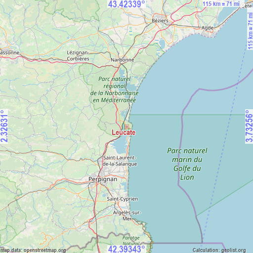
Leucate GPS coordinates[2]
42° 54' 38.016" North, 3° 1' 45.984" East
| Map corner | latitude | longitude |
|---|---|---|
| Upper-left | 43.42339°, | 2.32631° |
| Center: | 42.91056°, | 3.02944° |
| Lower-right: | 42.39343°, | 3.73256° |
| Map W x H: | 114.5×114.5 km | = 71.1×71.1mi |
| max Lat: | 51.07786° ⇑98.6% North |
| Leucate: | 42.91056° |
| min Lat: | ⇓1.4% South 41.3874° |
| min Long | Leucate | max Long |
| -5.08615° | 3.02944° | 9.52242° |
| W 58.2%⇐ | ⇒41.8% E |
Elevation
Elevation of Leucate is 30 m = 98 ft, and this is 163.7 m = 537 ft below average elevation for this country.
| Max E: |
2333 m = 7654 ft | 89.9% |
| Avg. | 193.7 m = 635 ft | |
| Leucate | 30 m = 98 ft | |
Min E: |
-1 m = -3 ft | 10.1% |
See also: France elevation on elevation.city.
Geographical zone
Leucate is located in North temperate zone (between Tropic of Cancer and the Arctic Circle). Distance of this Northern Tropic circle is 2165.3 km =1345.5 mi to South.| Distance of | km | miles | from Leucate |
|---|---|---|---|
| North Pole | 5235.9 | 3253.4 | to North |
| Arctic Circle | 2630 | 1634.2 | to North |
| Tropic Cancer | 2165.3 | 1345.5 | to South |
| Equator | 4771.2 | 2964.7 | to South |


Nearby cities:
15 places around Leucate: (largest is in red/bold)
• Caves
4.8 km =3 mi,  298°
298°
• Claira
17.7 km =11 mi,  199°
199°
• Durban-Corbières
19.8 km =12.3 mi, 298°
• Fitou
4.7 km =2.9 mi,  245°
245°
• La Palme
7.8 km =4.8 mi,  337°
337°
• Le Barcarès
13.7 km =8.5 mi,  177°
177°
• Opoul-Périllos
12.9 km =8 mi, 247°
• Port-la-Nouvelle
12.2 km =7.6 mi,  5°
5°
• Portel-des-Corbières
18 km =11.2 mi,  329°
329°
• Roquefort-des-Corbières
10.9 km =6.8 mi, 325°
• Saint-Hippolyte
14.8 km =9.2 mi, 200°
• Saint-Laurent-de-la-Salanque
15.7 km =9.8 mi,  191°
191°
• Salses-le-Château
12.6 km =7.8 mi,  226°
226°
• Sigean
13.7 km =8.5 mi, 342°
• Torreilles
17.6 km =10.9 mi, 189°
Sources, notices
• [Note1] Compared only with cities in France existing in our database
• [Src1] Map data: © OpenStreetMap contributors (CC-BY-SA)
• [Src2] Other city data from geonames.org with taken over terms of usage.
• [Src3] Geographical zone / Annual Mean Temperature by Robert A. Rohde @ Wikipedia
