Opoul-Périllos geodata
Opoul-Périllos (Occitanie) is a populated place; located in France in Europe/Paris (GMT+2) time zone. With population of 648 people, there are 12550 cities with bigger population in this country. Compared to other cities in France, 98.7% of cities are located further ↑North; 56.2% of cities are located further ←West and 55.9% of cities have lower elevation than Opoul-Périllos. Note1
Administrative division(s):
- Level 1: Occitanie
- Level 2: Département des Pyrénées-Orientales
- Level 3: Arrondissement de Perpignan
- Level 4: Opoul-Périllos


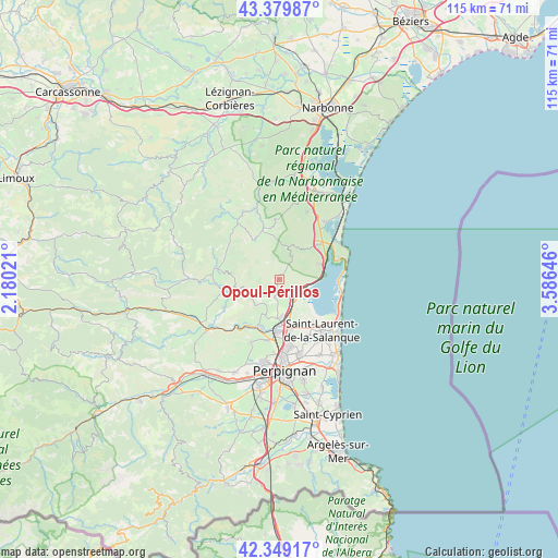
Opoul-Périllos GPS coordinates[2]
42° 52' 0.012" North, 2° 52' 59.988" East
| Map corner | latitude | longitude |
|---|---|---|
| Upper-left | 43.37987°, | 2.18021° |
| Center: | 42.86667°, | 2.88333° |
| Lower-right: | 42.34917°, | 3.58646° |
| Map W x H: | 114.6×114.6 km | = 71.2×71.2mi |
| max Lat: | 51.07786° ⇑98.7% North |
| Opoul-Périllos: | 42.86667° |
| min Lat: | ⇓1.3% South 41.3874° |
| min Long | Opoul-Périllos | max Long |
| -5.08615° | 2.88333° | 9.52242° |
| W 56.2%⇐ | ⇒43.8% E |
Elevation
Elevation of Opoul-Périllos is 153 m = 502 ft, and this is 40.7 m = 134 ft below average elevation for this country.
| Max E: |
2333 m = 7654 ft | 44.1% |
| Avg. | 193.7 m = 635 ft | |
| Opoul-Périllos | 153 m = 502 ft | |
Min E: |
-1 m = -3 ft | 55.9% |
See also: France elevation on elevation.city.
Geographical zone
Opoul-Périllos is located in North temperate zone (between Tropic of Cancer and the Arctic Circle). Distance of this Northern Tropic circle is 2160.4 km =1342.4 mi to South.| Distance of | km | miles | from Opoul-Périllos |
|---|---|---|---|
| North Pole | 5240.7 | 3256.4 | to North |
| Arctic Circle | 2634.8 | 1637.2 | to North |
| Tropic Cancer | 2160.4 | 1342.4 | to South |
| Equator | 4766.3 | 2961.6 | to South |


Nearby cities:
15 places around Opoul-Périllos: (largest is in red/bold)
• Cases-de-Pène
12.6 km =7.8 mi,  218°
218°
• Caves
10.5 km =6.5 mi,  46°
46°
• Claira
13.2 km =8.2 mi,  153°
153°
• Fitou
8.2 km =5.1 mi,  69°
69°
• Leucate
12.9 km =8 mi, 67°
• Paziols
13.4 km =8.3 mi,  266°
266°
• Peyrestortes
12.7 km =7.9 mi,  191°
191°
• Pia
13.9 km =8.6 mi,  167°
167°
• Rivesaltes
10.8 km =6.7 mi,  184°
184°
• Saint-Hippolyte
11.3 km =7 mi,  143°
143°
• Saint-Laurent-de-la-Salanque
13.6 km =8.5 mi, 140°
• Salses-le-Château
4.6 km =2.9 mi, 143°
• Tautavel
12.6 km =7.8 mi,  242°
242°
• Tuchan
13.6 km =8.5 mi,  280°
280°
• Vingrau
8.8 km =5.5 mi,  256°
256°
Sources, notices
• [Note1] Compared only with cities in France existing in our database
• [Src1] Map data: © OpenStreetMap contributors (CC-BY-SA)
• [Src2] Other city data from geonames.org with taken over terms of usage.
• [Src3] Geographical zone / Annual Mean Temperature by Robert A. Rohde @ Wikipedia
