Ferrières-Haut-Clocher geodata
Ferrières-Haut-Clocher (Normandy) is a populated place; located in France in Europe/Paris (GMT+2) time zone. With population of 804 people, there are 10564 cities with bigger population in this country. Compared to other cities in France, 80.2% of cities are located further ↓South; 68.9% of cities are located further →East and 52.8% of cities have lower elevation than Ferrières-Haut-Clocher. Note1
Administrative division(s):
- Level 1: Normandy
- Level 2: Département de l'Eure
- Level 3: Arrondissement d’Évreux
- Level 4: Ferrières-Haut-Clocher
Current local time in Ferrières-Haut-Clocher:
02:27 PM, SaturdayDifference from your time zone: hours


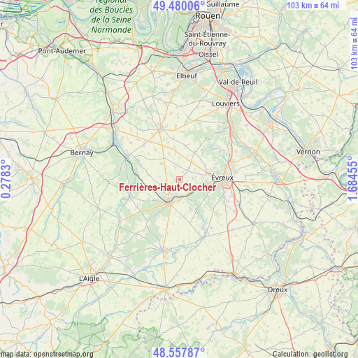
Ferrières-Haut-Clocher GPS coordinates[2]
49° 1' 15.96" North, 0° 58' 53.112" East
| Map corner | latitude | longitude |
|---|---|---|
| Upper-left | 49.48006°, | 0.2783° |
| Center: | 49.0211°, | 0.98142° |
| Lower-right: | 48.55787°, | 1.68455° |
| Map W x H: | 102.5×102.5 km | = 63.7×63.7mi |
| max Lat: | 51.07786° ⇑19.8% North |
| Ferrières-Haut-Clocher: | 49.0211° |
| min Lat: | ⇓80.2% South 41.3874° |
| min Long | Ferrières-Haut | max Long |
| -5.08615° | 0.98142° | 9.52242° |
| W 31.1%⇐ | ⇒68.9% E |
Elevation
Elevation of Ferrières-Haut-Clocher is 142 m = 466 ft, and this is 51.7 m = 170 ft below average elevation for this country.
| Max E: |
2333 m = 7654 ft | 47.2% |
| Avg. | 193.7 m = 635 ft | |
| Ferrières-Haut-Clocher | 142 m = 466 ft | |
Min E: |
-1 m = -3 ft | 52.8% |
See also: France elevation on elevation.city.
Geographical zone
Ferrières-Haut-Clocher is located in North temperate zone (between Tropic of Cancer and the Arctic Circle). Distance of this North polar circle is 1950.5 km =1212 mi to North.| Distance of | km | miles | from Ferrières-Haut-Clocher |
|---|---|---|---|
| North Pole | 4556.4 | 2831.2 | to North |
| Arctic Circle | 1950.5 | 1212 | to North |
| Tropic Cancer | 2844.7 | 1767.6 | to South |
| Equator | 5450.6 | 3386.8 | to South |


Nearby cities:
15 places around Ferrières-Haut-Clocher: (largest is in red/bold)
• Arnières-sur-Iton
9.3 km =5.8 mi,  106°
106°
• Aulnay-sur-Iton
6.3 km =3.9 mi,  116°
116°
• Aviron
10.4 km =6.5 mi,  71°
71°
• Caugé
3.8 km =2.4 mi,  84°
84°
• Claville
4.1 km =2.5 mi,  42°
42°
• Combon
10.6 km =6.6 mi,  321°
321°
• Conches-en-Ouche
7.7 km =4.8 mi,  202°
202°
• Gauville-la-Campagne
8.3 km =5.2 mi, 71°
• Glisolles
4.8 km =3 mi,  146°
146°
• La Bonneville-sur-Iton
4.5 km =2.8 mi, 121°
• Louversey
5.6 km =3.5 mi,  231°
231°
• Quittebeuf
10.2 km =6.3 mi,  14°
14°
• Sacquenville
9.7 km =6 mi, 43°
• Saint-Sébastien-de-Morsent
7.8 km =4.8 mi,  98°
98°
• Saint-Élier
4.2 km =2.6 mi, 197°
Sources, notices
• [Note1] Compared only with cities in France existing in our database
• [Src1] Map data: © OpenStreetMap contributors (CC-BY-SA)
• [Src2] Other city data from geonames.org with taken over terms of usage.
• [Src3] Geographical zone / Annual Mean Temperature by Robert A. Rohde @ Wikipedia
