Saint-Élier geodata
Saint-Élier (Normandy) is a populated place; located in France in Europe/Paris (GMT+2) time zone. With population of 528 people, there are 14653 cities with bigger population in this country. Compared to other cities in France, 79.3% of cities are located further ↓South; 69.1% of cities are located further →East and 52.5% of cities have lower elevation than Saint-Élier. Note1
Administrative division(s):
- Level 1: Normandy
- Level 2: Département de l'Eure
- Level 3: Arrondissement d’Évreux
- Level 4: Saint-Élier


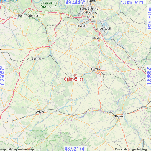
Saint-Élier GPS coordinates[2]
48° 59' 7.116" North, 0° 57' 49.32" East
| Map corner | latitude | longitude |
|---|---|---|
| Upper-left | 49.4446°, | 0.26057° |
| Center: | 48.98531°, | 0.9637° |
| Lower-right: | 48.52174°, | 1.66682° |
| Map W x H: | 102.6×102.6 km | = 63.8×63.8mi |
| max Lat: | 51.07786° ⇑20.7% North |
| Saint-Élier: | 48.98531° |
| min Lat: | ⇓79.3% South 41.3874° |
| min Long | Saint-Élier | max Long |
| -5.08615° | 0.9637° | 9.52242° |
| W 30.9%⇐ | ⇒69.1% E |
Elevation
Elevation of Saint-Élier is 141 m = 463 ft, and this is 52.7 m = 173 ft below average elevation for this country.
| Max E: |
2333 m = 7654 ft | 47.5% |
| Avg. | 193.7 m = 635 ft | |
| Saint-Élier | 141 m = 463 ft | |
Min E: |
-1 m = -3 ft | 52.5% |
See also: France elevation on elevation.city.
Geographical zone
Saint-Élier is located in North temperate zone (between Tropic of Cancer and the Arctic Circle). Distance of this North polar circle is 1954.5 km =1214.5 mi to North.| Distance of | km | miles | from Saint-Élier |
|---|---|---|---|
| North Pole | 4560.4 | 2833.7 | to North |
| Arctic Circle | 1954.5 | 1214.5 | to North |
| Tropic Cancer | 2840.7 | 1765.1 | to South |
| Equator | 5446.7 | 3384.4 | to South |


Nearby cities:
15 places around Saint-Élier: (largest is in red/bold)
• Arnières-sur-Iton
10.3 km =6.4 mi,  82°
82°
• Aulnay-sur-Iton
7.1 km =4.4 mi, 80°
• Aviron
13.3 km =8.3 mi,  57°
57°
• Caugé
6.7 km =4.2 mi,  49°
49°
• Claville
8.1 km =5 mi,  30°
30°
• Combon
13.4 km =8.3 mi,  336°
336°
• Conches-en-Ouche
3.5 km =2.2 mi,  208°
208°
• Ferrières-Haut-Clocher
4.2 km =2.6 mi,  17°
17°
• Gauville-la-Campagne
11.4 km =7.1 mi, 54°
• Glisolles
3.9 km =2.4 mi,  91°
91°
• La Bonneville-sur-Iton
5.3 km =3.3 mi,  72°
72°
• Le Fidelaire
11.6 km =7.2 mi,  249°
249°
• Le Plessis-Grohan
13 km =8.1 mi,  108°
108°
• Louversey
3.1 km =1.9 mi,  279°
279°
• Saint-Sébastien-de-Morsent
9.5 km =5.9 mi, 72°
Sources, notices
• [Note1] Compared only with cities in France existing in our database
• [Src1] Map data: © OpenStreetMap contributors (CC-BY-SA)
• [Src2] Other city data from geonames.org with taken over terms of usage.
• [Src3] Geographical zone / Annual Mean Temperature by Robert A. Rohde @ Wikipedia
