Claville geodata
Claville (Normandy) is a populated place; located in France in Europe/Paris (GMT+2) time zone. With population of 1,032 people, there are 8599 cities with bigger population in this country. Compared to other cities in France, 80.9% of cities are located further ↓South; 68.6% of cities are located further →East and 55.3% of cities have lower elevation than Claville. Note1
Administrative division(s):
- Level 1: Normandy
- Level 2: Département de l'Eure
- Level 3: Arrondissement d’Évreux
- Level 4: Claville


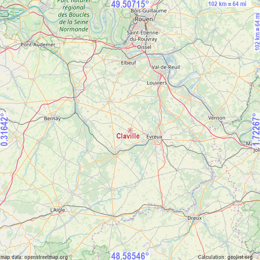
Claville GPS coordinates[2]
49° 2' 54.384" North, 1° 1' 10.344" East
| Map corner | latitude | longitude |
|---|---|---|
| Upper-left | 49.50715°, | 0.31642° |
| Center: | 49.04844°, | 1.01954° |
| Lower-right: | 48.58546°, | 1.72267° |
| Map W x H: | 102.5×102.5 km | = 63.7×63.7mi |
| max Lat: | 51.07786° ⇑19.1% North |
| Claville: | 49.04844° |
| min Lat: | ⇓80.9% South 41.3874° |
| min Long | Claville | max Long |
| -5.08615° | 1.01954° | 9.52242° |
| W 31.4%⇐ | ⇒68.6% E |
Elevation
Elevation of Claville is 151 m = 495 ft, and this is 42.7 m = 140 ft below average elevation for this country.
| Max E: |
2333 m = 7654 ft | 44.7% |
| Avg. | 193.7 m = 635 ft | |
| Claville | 151 m = 495 ft | |
Min E: |
-1 m = -3 ft | 55.3% |
See also: France elevation on elevation.city.
Geographical zone
Claville is located in North temperate zone (between Tropic of Cancer and the Arctic Circle). Distance of this North polar circle is 1947.5 km =1210.1 mi to North.| Distance of | km | miles | from Claville |
|---|---|---|---|
| North Pole | 4553.4 | 2829.4 | to North |
| Arctic Circle | 1947.5 | 1210.1 | to North |
| Tropic Cancer | 2847.8 | 1769.5 | to South |
| Equator | 5453.7 | 3388.8 | to South |


Nearby cities:
15 places around Claville: (largest is in red/bold)
• Arnières-sur-Iton
8.4 km =5.2 mi,  133°
133°
• Aulnay-sur-Iton
6.5 km =4 mi,  153°
153°
• Aviron
7.1 km =4.4 mi,  88°
88°
• Brosville
9.1 km =5.7 mi,  50°
50°
• Caugé
2.9 km =1.8 mi,  158°
158°
• Ferrières-Haut-Clocher
4.1 km =2.5 mi,  222°
222°
• Gauville-la-Campagne
5.1 km =3.2 mi, 93°
• Glisolles
7.1 km =4.4 mi,  181°
181°
• La Bonneville-sur-Iton
5.5 km =3.4 mi,  169°
169°
• Louversey
9.6 km =6 mi,  227°
227°
• Quittebeuf
6.8 km =4.2 mi,  357°
357°
• Sacquenville
5.6 km =3.5 mi,  44°
44°
• Saint-Sébastien-de-Morsent
6.5 km =4 mi, 130°
• Saint-Élier
8.1 km =5 mi,  210°
210°
• Évreux
9.9 km =6.2 mi,  105°
105°
Sources, notices
• [Note1] Compared only with cities in France existing in our database
• [Src1] Map data: © OpenStreetMap contributors (CC-BY-SA)
• [Src2] Other city data from geonames.org with taken over terms of usage.
• [Src3] Geographical zone / Annual Mean Temperature by Robert A. Rohde @ Wikipedia
