Saint-Sébastien-de-Morsent geodata
Saint-Sébastien-de-Morsent (Normandy) is a populated place; located in France in Europe/Paris (GMT+2) time zone. With population of 4,297 people, there are 2293 cities with bigger population in this country. Compared to other cities in France, 79.9% of cities are located further ↓South; 68% of cities are located further →East and 51.7% of cities have higher elevation than Saint-Sébastien-de-Morsent. Note1
Administrative division(s):
- Level 1: Normandy
- Level 2: Département de l'Eure
- Level 3: Arrondissement d’Évreux
- Level 4: Saint-Sébastien-de-Morsent
Current local time in Saint-Sébastien-de-Morsent:
09:01 AM, WednesdayDifference from your time zone: hours


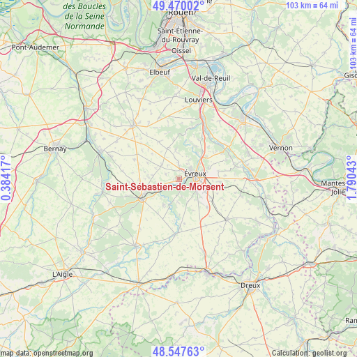
Saint-Sébastien-de-Morsent GPS coordinates[2]
49° 0' 39.456" North, 1° 5' 14.28" East
| Map corner | latitude | longitude |
|---|---|---|
| Upper-left | 49.47002°, | 0.38417° |
| Center: | 49.01096°, | 1.0873° |
| Lower-right: | 48.54763°, | 1.79043° |
| Map W x H: | 102.6×102.6 km | = 63.8×63.8mi |
| max Lat: | 51.07786° ⇑20.1% North |
| Saint-Sébastien-de-Morsent: | 49.01096° |
| min Lat: | ⇓79.9% South 41.3874° |
| min Long | Saint-Sébastie | max Long |
| -5.08615° | 1.0873° | 9.52242° |
| W 32%⇐ | ⇒68% E |
Elevation
Elevation of Saint-Sébastien-de-Morsent is 126 m = 413 ft, and this is 67.7 m = 222 ft below average elevation for this country.
| Max E: |
2333 m = 7654 ft | 51.7% |
| Avg. | 193.7 m = 635 ft | |
| Saint-Sébastien-de-Morsent | 126 m = 413 ft | |
Min E: |
-1 m = -3 ft | 48.3% |
See also: France elevation on elevation.city.
Geographical zone
Saint-Sébastien-de-Morsent is located in North temperate zone (between Tropic of Cancer and the Arctic Circle). Distance of this North polar circle is 1951.7 km =1212.7 mi to North.| Distance of | km | miles | from Saint-Sébastien-de-Morsent |
|---|---|---|---|
| North Pole | 4557.6 | 2832 | to North |
| Arctic Circle | 1951.7 | 1212.7 | to North |
| Tropic Cancer | 2843.6 | 1766.9 | to South |
| Equator | 5449.5 | 3386.2 | to South |


Nearby cities:
15 places around Saint-Sébastien-de-Morsent: (largest is in red/bold)
• Arnières-sur-Iton
2 km =1.2 mi,  142°
142°
• Aulnay-sur-Iton
2.6 km =1.6 mi,  230°
230°
• Aviron
4.8 km =3 mi,  26°
26°
• Caugé
4.2 km =2.6 mi,  291°
291°
• Claville
6.5 km =4 mi,  310°
310°
• Ferrières-Haut-Clocher
7.8 km =4.8 mi,  278°
278°
• Gauville-la-Campagne
3.8 km =2.4 mi,  2°
2°
• Glisolles
5.9 km =3.7 mi,  240°
240°
• Gravigny
7.6 km =4.7 mi,  52°
52°
• Guichainville
7.8 km =4.8 mi,  97°
97°
• Huest
9.1 km =5.7 mi,  70°
70°
• La Bonneville-sur-Iton
4.1 km =2.5 mi,  252°
252°
• Le Plessis-Grohan
7.8 km =4.8 mi,  155°
155°
• Sacquenville
8.2 km =5.1 mi,  352°
352°
• Évreux
4.9 km =3 mi, 72°
Sources, notices
• [Note1] Compared only with cities in France existing in our database
• [Src1] Map data: © OpenStreetMap contributors (CC-BY-SA)
• [Src2] Other city data from geonames.org with taken over terms of usage.
• [Src3] Geographical zone / Annual Mean Temperature by Robert A. Rohde @ Wikipedia
