Favières geodata
Favières (Grand Est) is a populated place; located in France in Europe/Paris (GMT+2) time zone. With population of 520 people, there are 14814 cities with bigger population in this country. Compared to other cities in France, 67.5% of cities are located further ↓South; 86.6% of cities are located further ←West and 84% of cities have lower elevation than Favières. Note1
Administrative division(s):
- Level 1: Grand Est
- Level 2: Meurthe-et-Moselle
- Level 3: Arrondissement de Toul
- Level 4: Favières


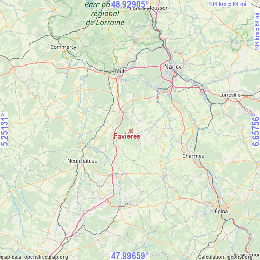
Favières GPS coordinates[2]
48° 27' 53.856" North, 5° 57' 15.948" East
| Map corner | latitude | longitude |
|---|---|---|
| Upper-left | 48.92905°, | 5.25131° |
| Center: | 48.46496°, | 5.95443° |
| Lower-right: | 47.99659°, | 6.65756° |
| Map W x H: | 103.7×103.7 km | = 64.4×64.4mi |
| max Lat: | 51.07786° ⇑32.5% North |
| Favières: | 48.46496° |
| min Lat: | ⇓67.5% South 41.3874° |
| min Long | Favières | max Long |
| -5.08615° | 5.95443° | 9.52242° |
| W 86.6%⇐ | ⇒13.4% E |
Elevation
Elevation of Favières is 335 m = 1099 ft, and this is 141.3 m = 464 ft above average elevation for this country.
| Max E: |
2333 m = 7654 ft | 16% |
| Favières | 335 m 1099 ft | |
| Avg. | 193.7 m = 635 ft | |
Min E: |
-1 m = -3 ft | 84% |
See also: France elevation on elevation.city.
Geographical zone
Favières is located in North temperate zone (between Tropic of Cancer and the Arctic Circle). Distance of this North polar circle is 2012.4 km =1250.4 mi to North.| Distance of | km | miles | from Favières |
|---|---|---|---|
| North Pole | 4618.3 | 2869.7 | to North |
| Arctic Circle | 2012.4 | 1250.4 | to North |
| Tropic Cancer | 2782.9 | 1729.2 | to South |
| Equator | 5388.8 | 3348.4 | to South |


Nearby cities:
15 places around Favières: (largest is in red/bold)
• Allamps
14 km =8.7 mi,  310°
310°
• Bainville-sur-Madon
17.1 km =10.6 mi,  37°
37°
• Blénod-lès-Toul
17.2 km =10.7 mi,  329°
329°
• Ceintrey
16.8 km =10.4 mi,  66°
66°
• Colombey-les-Belles
8.4 km =5.2 mi, 328°
• Frolois
16.8 km =10.4 mi,  48°
48°
• Gironcourt-sur-Vraine
17.2 km =10.7 mi,  185°
185°
• Maizières
15.2 km =9.4 mi,  30°
30°
• Pulligny
16.2 km =10.1 mi,  59°
59°
• Tantonville
13.6 km =8.5 mi,  87°
87°
• Thuilley-aux-Groseilles
12.2 km =7.6 mi,  6°
6°
• Vannes-le-Châtel
15.5 km =9.6 mi, 305°
• Viterne
14.8 km =9.2 mi,  22°
22°
• Vézelise
10.2 km =6.3 mi,  75°
75°
• Xeuilley
15.5 km =9.6 mi, 43°
Sources, notices
• [Note1] Compared only with cities in France existing in our database
• [Src1] Map data: © OpenStreetMap contributors (CC-BY-SA)
• [Src2] Other city data from geonames.org with taken over terms of usage.
• [Src3] Geographical zone / Annual Mean Temperature by Robert A. Rohde @ Wikipedia
