Fargues-Saint-Hilaire geodata
Fargues-Saint-Hilaire (Nouvelle-Aquitaine) is a populated place; located in France in Europe/Paris (GMT+2) time zone. With population of 1,351 people, there are 6807 cities with bigger population in this country. Compared to other cities in France, 81.2% of cities are located further ↑North; 82.7% of cities are located further →East and 67.4% of cities have higher elevation than Fargues-Saint-Hilaire. Note1
Administrative division(s):
- Level 1: Nouvelle-Aquitaine
- Level 2: Gironde
- Level 3: Arrondissement de Bordeaux
- Level 4: Fargues-Saint-Hilaire
Current local time in Fargues-Saint-Hilaire:
07:20 AM, SaturdayDifference from your time zone: hours


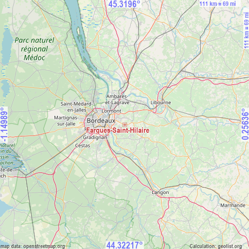
Fargues-Saint-Hilaire GPS coordinates[2]
44° 49' 22.944" North, 0° 26' 48.336" West
| Map corner | latitude | longitude |
|---|---|---|
| Upper-left | 45.3196°, | -1.14989° |
| Center: | 44.82304°, | -0.44676° |
| Lower-right: | 44.32217°, | 0.25636° |
| Map W x H: | 110.9×110.9 km | = 68.9×68.9mi |
| max Lat: | 51.07786° ⇑81.2% North |
| Fargues-Saint-Hilaire: | 44.82304° |
| min Lat: | ⇓18.8% South 41.3874° |
| min Long | Fargues-Saint-H | max Long |
| -5.08615° | -0.44676° | 9.52242° |
| W 17.3%⇐ | ⇒82.7% E |
Elevation
Elevation of Fargues-Saint-Hilaire is 84 m = 276 ft, and this is 109.7 m = 360 ft below average elevation for this country.
| Max E: |
2333 m = 7654 ft | 67.4% |
| Avg. | 193.7 m = 635 ft | |
| Fargues-Saint-Hilaire | 84 m = 276 ft | |
Min E: |
-1 m = -3 ft | 32.6% |
See also: France elevation on elevation.city.
Geographical zone
Fargues-Saint-Hilaire is located in North temperate zone (between Tropic of Cancer and the Arctic Circle). Distance of this Northern Tropic circle is 2377.9 km =1477.6 mi to South.| Distance of | km | miles | from Fargues-Saint-Hilaire |
|---|---|---|---|
| North Pole | 5023.2 | 3121.3 | to North |
| Arctic Circle | 2417.3 | 1502 | to North |
| Tropic Cancer | 2377.9 | 1477.6 | to South |
| Equator | 4983.9 | 3096.9 | to South |


Nearby cities:
15 places around Fargues-Saint-Hilaire: (largest is in red/bold)
• Artigues-près-Bordeaux
6.3 km =3.9 mi,  298°
298°
• Bonnetan
2.6 km =1.6 mi,  109°
109°
• Bouliac
4.4 km =2.7 mi,  261°
261°
• Carignan-de-Bordeaux
3.9 km =2.4 mi,  228°
228°
• Cénac
4.9 km =3 mi,  192°
192°
• Floirac
5.4 km =3.4 mi,  281°
281°
• Latresne
5.3 km =3.3 mi,  219°
219°
• Lignan-de-Bordeaux
3.3 km =2.1 mi,  152°
152°
• Loupes
4.9 km =3 mi, 107°
• Montussan
6.7 km =4.2 mi,  17°
17°
• Pompignac
3.2 km =2 mi,  13°
13°
• Sadirac
5.3 km =3.3 mi, 150°
• Sallebœuf
3.9 km =2.4 mi,  72°
72°
• Tresses
3 km =1.9 mi,  335°
335°
• Yvrac
6.2 km =3.9 mi,  351°
351°
Sources, notices
• [Note1] Compared only with cities in France existing in our database
• [Src1] Map data: © OpenStreetMap contributors (CC-BY-SA)
• [Src2] Other city data from geonames.org with taken over terms of usage.
• [Src3] Geographical zone / Annual Mean Temperature by Robert A. Rohde @ Wikipedia
