Illange geodata
Illange (Grand Est) is a populated place; located in France in Europe/Paris (GMT+2) time zone. With population of 2,190 people, there are 4386 cities with bigger population in this country. Compared to other cities in France, 86.6% of cities are located further ↓South; 89.1% of cities are located further ←West and 66.4% of cities have lower elevation than Illange. Note1
Administrative division(s):
- Level 1: Grand Est
- Level 2: Moselle
- Level 3: Arrondissement de Thionville
- Level 4: Illange


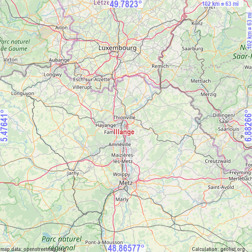
Illange GPS coordinates[2]
49° 19' 34.212" North, 6° 10' 46.308" East
| Map corner | latitude | longitude |
|---|---|---|
| Upper-left | 49.7823°, | 5.47641° |
| Center: | 49.32617°, | 6.17953° |
| Lower-right: | 48.86577°, | 6.88266° |
| Map W x H: | 101.9×101.9 km | = 63.3×63.3mi |
| max Lat: | 51.07786° ⇑13.4% North |
| Illange: | 49.32617° |
| min Lat: | ⇓86.6% South 41.3874° |
| min Long | Illange | max Long |
| -5.08615° | 6.17953° | 9.52242° |
| W 89.1%⇐ | ⇒10.9% E |
Elevation
Elevation of Illange is 201 m = 659 ft, and this is 7.3 m = 24 ft above average elevation for this country.
| Max E: |
2333 m = 7654 ft | 33.6% |
| Illange | 201 m 659 ft | |
| Avg. | 193.7 m = 635 ft | |
Min E: |
-1 m = -3 ft | 66.4% |
See also: France elevation on elevation.city.
Geographical zone
Illange is located in North temperate zone (between Tropic of Cancer and the Arctic Circle). Distance of this North polar circle is 1916.6 km =1190.9 mi to North.| Distance of | km | miles | from Illange |
|---|---|---|---|
| North Pole | 4522.5 | 2810.2 | to North |
| Arctic Circle | 1916.6 | 1190.9 | to North |
| Tropic Cancer | 2878.6 | 1788.7 | to South |
| Equator | 5484.6 | 3408 | to South |


Nearby cities:
15 places around Illange: (largest is in red/bold)
• Bertrange
1.7 km =1.1 mi,  146°
146°
• Bousse
5.5 km =3.4 mi,  166°
166°
• Distroff
6.4 km =4 mi,  83°
83°
• Fameck
5.9 km =3.7 mi,  239°
239°
• Florange
4.2 km =2.6 mi,  266°
266°
• Guénange
3.5 km =2.2 mi, 147°
• Kuntzig
4.8 km =3 mi,  60°
60°
• Manom
5 km =3.1 mi,  3°
3°
• Richemont
5.6 km =3.5 mi,  191°
191°
• Stuckange
4.2 km =2.6 mi,  89°
89°
• Terville
4 km =2.5 mi,  304°
304°
• Thionville
4 km =2.5 mi,  339°
339°
• Uckange
3.4 km =2.1 mi,  220°
220°
• Volstroff
6 km =3.7 mi,  105°
105°
• Yutz
3.4 km =2.1 mi,  16°
16°
Sources, notices
• [Note1] Compared only with cities in France existing in our database
• [Src1] Map data: © OpenStreetMap contributors (CC-BY-SA)
• [Src2] Other city data from geonames.org with taken over terms of usage.
• [Src3] Geographical zone / Annual Mean Temperature by Robert A. Rohde @ Wikipedia
