Serémange-Erzange geodata
Serémange-Erzange (Grand Est) is a populated place; located in France in Europe/Paris (GMT+2) time zone. With population of 4,030 people, there are 2436 cities with bigger population in this country. Compared to other cities in France, 86.5% of cities are located further ↓South; 88.1% of cities are located further ←West and 61.6% of cities have lower elevation than Serémange-Erzange. Note1
Administrative division(s):
- Level 1: Grand Est
- Level 2: Moselle
- Level 3: Arrondissement de Thionville
- Level 4: Serémange-Erzange


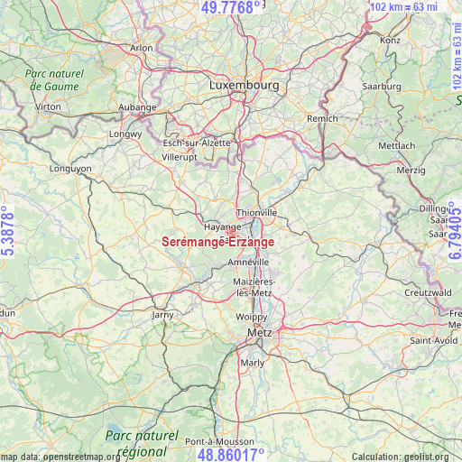
Serémange-Erzange GPS coordinates[2]
49° 19' 14.232" North, 6° 5' 27.312" East
| Map corner | latitude | longitude |
|---|---|---|
| Upper-left | 49.7768°, | 5.3878° |
| Center: | 49.32062°, | 6.09092° |
| Lower-right: | 48.86017°, | 6.79405° |
| Map W x H: | 101.9×101.9 km | = 63.3×63.3mi |
| max Lat: | 51.07786° ⇑13.5% North |
| Serémange-Erzange: | 49.32062° |
| min Lat: | ⇓86.5% South 41.3874° |
| min Long | Serémange-Erza | max Long |
| -5.08615° | 6.09092° | 9.52242° |
| W 88.1%⇐ | ⇒11.9% E |
Elevation
Elevation of Serémange-Erzange is 178 m = 584 ft, and this is 15.7 m = 52 ft below average elevation for this country.
| Max E: |
2333 m = 7654 ft | 38.4% |
| Avg. | 193.7 m = 635 ft | |
| Serémange-Erzange | 178 m = 584 ft | |
Min E: |
-1 m = -3 ft | 61.6% |
See also: France elevation on elevation.city.
Geographical zone
Serémange-Erzange is located in North temperate zone (between Tropic of Cancer and the Arctic Circle). Distance of this North polar circle is 1917.2 km =1191.3 mi to North.| Distance of | km | miles | from Serémange-Erzange |
|---|---|---|---|
| North Pole | 4523.1 | 2810.5 | to North |
| Arctic Circle | 1917.2 | 1191.3 | to North |
| Tropic Cancer | 2878 | 1788.3 | to South |
| Equator | 5483.9 | 3407.5 | to South |


Nearby cities:
15 places around Serémange-Erzange: (largest is in red/bold)
• Algrange
5.5 km =3.4 mi,  328°
328°
• Clouange
6.5 km =4 mi,  175°
175°
• Fameck
2.7 km =1.7 mi,  151°
151°
• Florange
2.2 km =1.4 mi,  81°
81°
• Gandrange
6 km =3.7 mi,  155°
155°
• Hayange
2.2 km =1.4 mi,  294°
294°
• Illange
6.5 km =4 mi, 84°
• Knutange
4.3 km =2.7 mi,  298°
298°
• Neufchef
4.9 km =3 mi,  264°
264°
• Nilvange
3.8 km =2.4 mi,  308°
308°
• Ranguevaux
3.7 km =2.3 mi,  225°
225°
• Terville
4.2 km =2.6 mi,  46°
46°
• Thionville
6.7 km =4.2 mi, 49°
• Uckange
4.7 km =2.9 mi,  114°
114°
• Vitry-sur-Orne
6.2 km =3.9 mi,  166°
166°
Sources, notices
• [Note1] Compared only with cities in France existing in our database
• [Src1] Map data: © OpenStreetMap contributors (CC-BY-SA)
• [Src2] Other city data from geonames.org with taken over terms of usage.
• [Src3] Geographical zone / Annual Mean Temperature by Robert A. Rohde @ Wikipedia
