Eymeux geodata
Eymeux (Auvergne-Rhône-Alpes) is a populated place; located in France in Europe/Paris (GMT+2) time zone. With population of 615 people, there are 13071 cities with bigger population in this country. Compared to other cities in France, 78.8% of cities are located further ↑North; 79.5% of cities are located further ←West and 64.2% of cities have lower elevation than Eymeux. Note1
Administrative division(s):
- Level 1: Auvergne-Rhône-Alpes
- Level 2: Département de la Drôme
- Level 3: Arrondissement de Valence
- Level 4: Eymeux


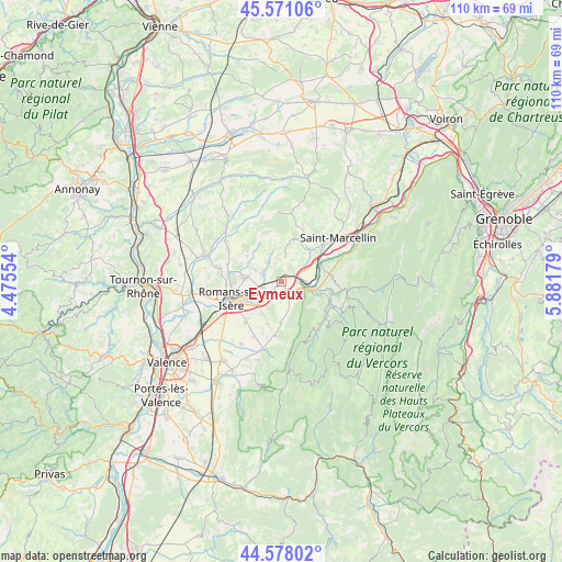
Eymeux GPS coordinates[2]
45° 4' 36.12" North, 5° 10' 43.176" East
| Map corner | latitude | longitude |
|---|---|---|
| Upper-left | 45.57106°, | 4.47554° |
| Center: | 45.0767°, | 5.17866° |
| Lower-right: | 44.57802°, | 5.88179° |
| Map W x H: | 110.4×110.4 km | = 68.6×68.6mi |
| max Lat: | 51.07786° ⇑78.8% North |
| Eymeux: | 45.0767° |
| min Lat: | ⇓21.2% South 41.3874° |
| min Long | Eymeux | max Long |
| -5.08615° | 5.17866° | 9.52242° |
| W 79.5%⇐ | ⇒20.5% E |
Elevation
Elevation of Eymeux is 190 m = 623 ft, and this is 3.7 m = 12 ft below average elevation for this country.
| Max E: |
2333 m = 7654 ft | 35.8% |
| Avg. | 193.7 m = 635 ft | |
| Eymeux | 190 m = 623 ft | |
Min E: |
-1 m = -3 ft | 64.2% |
See also: France elevation on elevation.city.
Geographical zone
Eymeux is located in North temperate zone (between Tropic of Cancer and the Arctic Circle). Distance of this North polar circle is 2389.1 km =1484.5 mi to North.| Distance of | km | miles | from Eymeux |
|---|---|---|---|
| North Pole | 4995 | 3103.7 | to North |
| Arctic Circle | 2389.1 | 1484.5 | to North |
| Tropic Cancer | 2406.1 | 1495.1 | to South |
| Equator | 5012.1 | 3114.4 | to South |


Nearby cities:
15 places around Eymeux: (largest is in red/bold)
• Beauregard
8.9 km =5.5 mi,  175°
175°
• Châtillon-Saint-Jean
4 km =2.5 mi,  287°
287°
• Geyssans
8.3 km =5.2 mi,  305°
305°
• Génissieux
7.7 km =4.8 mi,  276°
276°
• Hostun
5.1 km =3.2 mi,  160°
160°
• Jaillans
5.3 km =3.3 mi, 183°
• La Sône
8.7 km =5.4 mi,  63°
63°
• Parnans
4.6 km =2.9 mi,  322°
322°
• Romans-sur-Isère
9.3 km =5.8 mi,  251°
251°
• Saint-Bonnet-de-Chavagne
6.9 km =4.3 mi,  37°
37°
• Saint-Hilaire-du-Rosier
6.1 km =3.8 mi,  65°
65°
• Saint-Just-de-Claix
8.2 km =5.1 mi,  90°
90°
• Saint-Lattier
2.3 km =1.4 mi, 56°
• Saint-Nazaire-en-Royans
5.9 km =3.7 mi,  108°
108°
• Saint-Paul-lès-Romans
3.8 km =2.4 mi, 253°
Sources, notices
• [Note1] Compared only with cities in France existing in our database
• [Src1] Map data: © OpenStreetMap contributors (CC-BY-SA)
• [Src2] Other city data from geonames.org with taken over terms of usage.
• [Src3] Geographical zone / Annual Mean Temperature by Robert A. Rohde @ Wikipedia
