Saint-Lattier geodata
Saint-Lattier (Auvergne-Rhône-Alpes) is a populated place; located in France in Europe/Paris (GMT+2) time zone. With population of 1,119 people, there are 8016 cities with bigger population in this country. Compared to other cities in France, 78.7% of cities are located further ↑North; 79.8% of cities are located further ←West and 62.1% of cities have lower elevation than Saint-Lattier. Note1
Administrative division(s):
- Level 1: Auvergne-Rhône-Alpes
- Level 2: Département de l'Isère
- Level 3: Arrondissement de Grenoble
- Level 4: Saint-Lattier


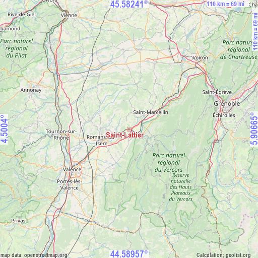
Saint-Lattier GPS coordinates[2]
45° 5' 17.34" North, 5° 12' 12.672" East
| Map corner | latitude | longitude |
|---|---|---|
| Upper-left | 45.58241°, | 4.5004° |
| Center: | 45.08815°, | 5.20352° |
| Lower-right: | 44.58957°, | 5.90665° |
| Map W x H: | 110.4×110.4 km | = 68.6×68.6mi |
| max Lat: | 51.07786° ⇑78.7% North |
| Saint-Lattier: | 45.08815° |
| min Lat: | ⇓21.3% South 41.3874° |
| min Long | Saint-Lattier | max Long |
| -5.08615° | 5.20352° | 9.52242° |
| W 79.8%⇐ | ⇒20.2% E |
Elevation
Elevation of Saint-Lattier is 180 m = 591 ft, and this is 13.7 m = 45 ft below average elevation for this country.
| Max E: |
2333 m = 7654 ft | 37.9% |
| Avg. | 193.7 m = 635 ft | |
| Saint-Lattier | 180 m = 591 ft | |
Min E: |
-1 m = -3 ft | 62.1% |
See also: France elevation on elevation.city.
Geographical zone
Saint-Lattier is located in North temperate zone (between Tropic of Cancer and the Arctic Circle). Distance of this North polar circle is 2387.8 km =1483.7 mi to North.| Distance of | km | miles | from Saint-Lattier |
|---|---|---|---|
| North Pole | 4993.7 | 3102.9 | to North |
| Arctic Circle | 2387.8 | 1483.7 | to North |
| Tropic Cancer | 2407.4 | 1495.9 | to South |
| Equator | 5013.3 | 3115.1 | to South |


Nearby cities:
15 places around Saint-Lattier: (largest is in red/bold)
• Chatte
8.6 km =5.3 mi,  45°
45°
• Châtillon-Saint-Jean
5.8 km =3.6 mi,  269°
269°
• Eymeux
2.3 km =1.4 mi,  236°
236°
• Geyssans
9.4 km =5.8 mi,  292°
292°
• Hostun
6.1 km =3.8 mi,  182°
182°
• Jaillans
6.9 km =4.3 mi,  199°
199°
• La Sône
6.4 km =4 mi,  66°
66°
• Parnans
5.3 km =3.3 mi,  296°
296°
• Saint-Antoine-l'Abbaye
8.8 km =5.5 mi,  6°
6°
• Saint-Bonnet-de-Chavagne
4.8 km =3 mi,  27°
27°
• Saint-Hilaire-du-Rosier
3.8 km =2.4 mi, 70°
• Saint-Just-de-Claix
6.4 km =4 mi,  102°
102°
• Saint-Nazaire-en-Royans
4.8 km =3 mi,  130°
130°
• Saint-Paul-lès-Romans
6.1 km =3.8 mi,  247°
247°
• Saint-Thomas-en-Royans
8.4 km =5.2 mi,  121°
121°
Sources, notices
• [Note1] Compared only with cities in France existing in our database
• [Src1] Map data: © OpenStreetMap contributors (CC-BY-SA)
• [Src2] Other city data from geonames.org with taken over terms of usage.
• [Src3] Geographical zone / Annual Mean Temperature by Robert A. Rohde @ Wikipedia
