Étréchy geodata
Étréchy (Île-de-France) is a populated place; located in France in Europe/Paris (GMT+2) time zone. With population of 6,461 people, there are 1529 cities with bigger population in this country. Compared to other cities in France, 68.2% of cities are located further ↓South; 54.5% of cities are located further →East and 69.7% of cities have higher elevation than Étréchy. Note1
Administrative division(s):
- Level 1: Île-de-France
- Level 2: Département de l'Essonne
- Level 3: Arrondissement d'Étampes
- Level 4: Étréchy


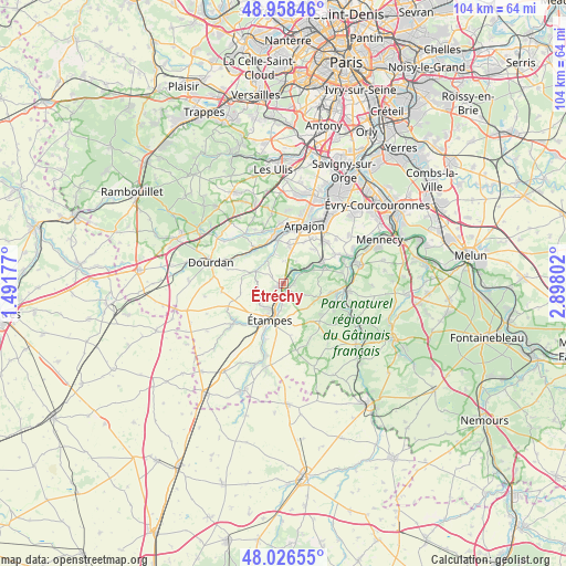
Étréchy GPS coordinates[2]
48° 29' 40.74" North, 2° 11' 41.604" East
| Map corner | latitude | longitude |
|---|---|---|
| Upper-left | 48.95846°, | 1.49177° |
| Center: | 48.49465°, | 2.19489° |
| Lower-right: | 48.02655°, | 2.89802° |
| Map W x H: | 103.6×103.6 km | = 64.4×64.4mi |
| max Lat: | 51.07786° ⇑31.8% North |
| Étréchy: | 48.49465° |
| min Lat: | ⇓68.2% South 41.3874° |
| min Long | Étréchy | max Long |
| -5.08615° | 2.19489° | 9.52242° |
| W 45.5%⇐ | ⇒54.5% E |
Elevation
Elevation of Étréchy is 79 m = 259 ft, and this is 114.7 m = 376 ft below average elevation for this country.
| Max E: |
2333 m = 7654 ft | 69.7% |
| Avg. | 193.7 m = 635 ft | |
| Étréchy | 79 m = 259 ft | |
Min E: |
-1 m = -3 ft | 30.3% |
See also: France elevation on elevation.city.
Geographical zone
Étréchy is located in North temperate zone (between Tropic of Cancer and the Arctic Circle). Distance of this North polar circle is 2009.1 km =1248.4 mi to North.| Distance of | km | miles | from Étréchy |
|---|---|---|---|
| North Pole | 4615 | 2867.6 | to North |
| Arctic Circle | 2009.1 | 1248.4 | to North |
| Tropic Cancer | 2786.2 | 1731.3 | to South |
| Equator | 5392.1 | 3350.5 | to South |


Nearby cities:
15 places around Étréchy: (largest is in red/bold)
• Auvers-Saint-Georges
1.9 km =1.2 mi,  96°
96°
• Boissy-le-Cutté
7.1 km =4.4 mi,  112°
112°
• Boissy-le-Sec
7.9 km =4.9 mi,  256°
256°
• Boissy-sous-Saint-Yon
6.7 km =4.2 mi,  10°
10°
• Bouray-sur-Juine
8.2 km =5.1 mi,  70°
70°
• Brières-les-Scellés
6 km =3.7 mi,  225°
225°
• Chamarande
3 km =1.9 mi,  33°
33°
• Janville-sur-Juine
6 km =3.7 mi, 69°
• Lardy
6.4 km =4 mi, 65°
• Morigny-Champigny
5.4 km =3.4 mi,  188°
188°
• Saint-Chéron
8.4 km =5.2 mi,  321°
321°
• Saint-Yon
7.1 km =4.4 mi,  357°
357°
• Villeconin
5.6 km =3.5 mi,  293°
293°
• Villeneuve-sur-Auvers
4.5 km =2.8 mi,  119°
119°
• Étampes
7 km =4.3 mi,  199°
199°
Sources, notices
• [Note1] Compared only with cities in France existing in our database
• [Src1] Map data: © OpenStreetMap contributors (CC-BY-SA)
• [Src2] Other city data from geonames.org with taken over terms of usage.
• [Src3] Geographical zone / Annual Mean Temperature by Robert A. Rohde @ Wikipedia
