Courchelettes geodata
Courchelettes (Hauts-de-France) is a populated place; located in France in Europe/Paris (GMT+2) time zone. With population of 2,919 people, there are 3337 cities with bigger population in this country. Compared to other cities in France, 95.9% of cities are located further ↓South; 58.6% of cities are located further ←West and 89.9% of cities have higher elevation than Courchelettes. Note1
Administrative division(s):
- Level 1: Hauts-de-France
- Level 2: Nord
- Level 3: Arrondissement de Douai
- Level 4: Courchelettes


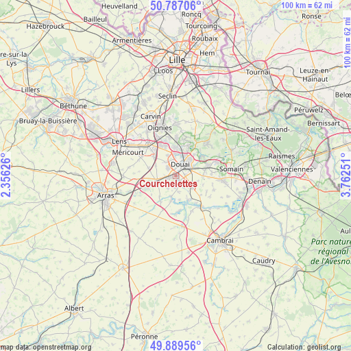
Courchelettes GPS coordinates[2]
50° 20' 25.548" North, 3° 3' 33.768" East
| Map corner | latitude | longitude |
|---|---|---|
| Upper-left | 50.78706°, | 2.35626° |
| Center: | 50.34043°, | 3.05938° |
| Lower-right: | 49.88956°, | 3.76251° |
| Map W x H: | 99.8×99.8 km | = 62×62mi |
| max Lat: | 51.07786° ⇑4.1% North |
| Courchelettes: | 50.34043° |
| min Lat: | ⇓95.9% South 41.3874° |
| min Long | Courchelettes | max Long |
| -5.08615° | 3.05938° | 9.52242° |
| W 58.6%⇐ | ⇒41.4% E |
Elevation
Elevation of Courchelettes is 30 m = 98 ft, and this is 163.7 m = 537 ft below average elevation for this country.
| Max E: |
2333 m = 7654 ft | 89.9% |
| Avg. | 193.7 m = 635 ft | |
| Courchelettes | 30 m = 98 ft | |
Min E: |
-1 m = -3 ft | 10.1% |
See also: France elevation on elevation.city.
Geographical zone
Courchelettes is located in North temperate zone (between Tropic of Cancer and the Arctic Circle). Distance of this North polar circle is 1803.8 km =1120.8 mi to North.| Distance of | km | miles | from Courchelettes |
|---|---|---|---|
| North Pole | 4409.7 | 2740.1 | to North |
| Arctic Circle | 1803.8 | 1120.8 | to North |
| Tropic Cancer | 2991.4 | 1858.8 | to South |
| Equator | 5597.3 | 3478 | to South |


Nearby cities:
15 places around Courchelettes: (largest is in red/bold)
• Brebières
3.1 km =1.9 mi,  255°
255°
• Corbehem
1.2 km =0.7 mi,  213°
213°
• Cuincy
4.3 km =2.7 mi,  354°
354°
• Dechy
4.2 km =2.6 mi,  75°
75°
• Douai
3.6 km =2.2 mi,  22°
22°
• Esquerchin
5.1 km =3.2 mi,  320°
320°
• Estrées
4.5 km =2.8 mi,  170°
170°
• Férin
1.8 km =1.1 mi,  144°
144°
• Gouy-sous-Bellonne
3.2 km =2 mi,  183°
183°
• Gœulzin
3.9 km =2.4 mi,  132°
132°
• Lambres-lez-Douai
1.2 km =0.7 mi,  25°
25°
• Lauwin-Planque
5.6 km =3.5 mi, 349°
• Noyelles-sous-Bellonne
4.2 km =2.6 mi, 212°
• Sin-le-Noble
5.6 km =3.5 mi,  65°
65°
• Vitry-en-Artois
5.8 km =3.6 mi,  254°
254°
Sources, notices
• [Note1] Compared only with cities in France existing in our database
• [Src1] Map data: © OpenStreetMap contributors (CC-BY-SA)
• [Src2] Other city data from geonames.org with taken over terms of usage.
• [Src3] Geographical zone / Annual Mean Temperature by Robert A. Rohde @ Wikipedia
