Estouteville-Écalles geodata
Estouteville-Écalles (Normandy) is a populated place; located in France in Europe/Paris (GMT+2) time zone. With population of 502 people, there are 15200 cities with bigger population in this country. Compared to other cities in France, 90.4% of cities are located further ↓South; 65.4% of cities are located further →East and 64.4% of cities have lower elevation than Estouteville-Écalles. Note1
Administrative division(s):
- Level 1: Normandy
- Level 2: Seine-Maritime
- Level 3: Arrondissement de Rouen
- Level 4: Buchy


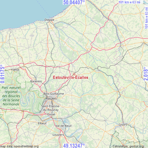
Estouteville-Écalles GPS coordinates[2]
49° 35' 25.44" North, 1° 18' 53.532" East
| Map corner | latitude | longitude |
|---|---|---|
| Upper-left | 50.04407°, | 0.61175° |
| Center: | 49.5904°, | 1.31487° |
| Lower-right: | 49.13247°, | 2.018° |
| Map W x H: | 101.4×101.4 km | = 63×63mi |
| max Lat: | 51.07786° ⇑9.6% North |
| Estouteville-Écalles: | 49.5904° |
| min Lat: | ⇓90.4% South 41.3874° |
| min Long | Estouteville-É | max Long |
| -5.08615° | 1.31487° | 9.52242° |
| W 34.6%⇐ | ⇒65.4% E |
Elevation
Elevation of Estouteville-Écalles is 191 m = 627 ft, and this is 2.7 m = 9 ft below average elevation for this country.
| Max E: |
2333 m = 7654 ft | 35.6% |
| Avg. | 193.7 m = 635 ft | |
| Estouteville-Écalles | 191 m = 627 ft | |
Min E: |
-1 m = -3 ft | 64.4% |
See also: France elevation on elevation.city.
Geographical zone
Estouteville-Écalles is located in North temperate zone (between Tropic of Cancer and the Arctic Circle). Distance of this North polar circle is 1887.2 km =1172.7 mi to North.| Distance of | km | miles | from Estouteville-Écalles |
|---|---|---|---|
| North Pole | 4493.1 | 2791.9 | to North |
| Arctic Circle | 1887.2 | 1172.7 | to North |
| Tropic Cancer | 2908 | 1806.9 | to South |
| Equator | 5513.9 | 3426.2 | to South |


Nearby cities:
15 places around Estouteville-Écalles: (largest is in red/bold)
• Blainville-Crevon
9.7 km =6 mi,  186°
186°
• Bosc-le-Hard
10.9 km =6.8 mi,  292°
292°
• Buchy
3.2 km =2 mi,  100°
100°
• Catenay
8.7 km =5.4 mi,  173°
173°
• Fontaine-le-Bourg
11.3 km =7 mi,  255°
255°
• Montérolier
5.1 km =3.2 mi,  26°
26°
• Morgny-la-Pommeraye
9.8 km =6.1 mi,  205°
205°
• Rocquemont
2.7 km =1.7 mi,  302°
302°
• Saint-André-sur-Cailly
8.4 km =5.2 mi,  234°
234°
• Saint-Georges-sur-Fontaine
11 km =6.8 mi,  241°
241°
• Saint-Martin-Osmonville
5.5 km =3.4 mi,  348°
348°
• Saint-Saëns
9.4 km =5.8 mi, 346°
• Sainte-Croix-sur-Buchy
3.9 km =2.4 mi,  138°
138°
• Sommery
10.3 km =6.4 mi,  61°
61°
• Vieux-Manoir
2.8 km =1.7 mi, 208°
Sources, notices
• [Note1] Compared only with cities in France existing in our database
• [Src1] Map data: © OpenStreetMap contributors (CC-BY-SA)
• [Src2] Other city data from geonames.org with taken over terms of usage.
• [Src3] Geographical zone / Annual Mean Temperature by Robert A. Rohde @ Wikipedia
