Esquéhéries geodata
Esquéhéries (Hauts-de-France) is a populated place; located in France in Europe/Paris (GMT+2) time zone. With population of 1,222 people, there are 7424 cities with bigger population in this country. Compared to other cities in France, 93.5% of cities are located further ↓South; 66% of cities are located further ←West and 59.8% of cities have lower elevation than Esquéhéries. Note1
Administrative division(s):
- Level 1: Hauts-de-France
- Level 2: Département de l'Aisne
- Level 3: Arrondissement de Vervins
- Level 4: Esquéhéries


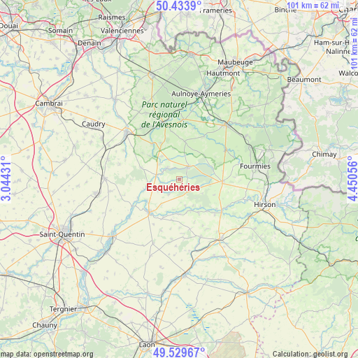
Esquéhéries GPS coordinates[2]
49° 59' 2.076" North, 3° 44' 50.748" East
| Map corner | latitude | longitude |
|---|---|---|
| Upper-left | 50.4339°, | 3.04431° |
| Center: | 49.98391°, | 3.74743° |
| Lower-right: | 49.52967°, | 4.45056° |
| Map W x H: | 100.5×100.5 km | = 62.4×62.4mi |
| max Lat: | 51.07786° ⇑6.5% North |
| Esquéhéries: | 49.98391° |
| min Lat: | ⇓93.5% South 41.3874° |
| min Long | Esquéhéries | max Long |
| -5.08615° | 3.74743° | 9.52242° |
| W 66%⇐ | ⇒34% E |
Elevation
Elevation of Esquéhéries is 169 m = 554 ft, and this is 24.7 m = 81 ft below average elevation for this country.
| Max E: |
2333 m = 7654 ft | 40.2% |
| Avg. | 193.7 m = 635 ft | |
| Esquéhéries | 169 m = 554 ft | |
Min E: |
-1 m = -3 ft | 59.8% |
See also: France elevation on elevation.city.
Geographical zone
Esquéhéries is located in North temperate zone (between Tropic of Cancer and the Arctic Circle). Distance of this North polar circle is 1843.5 km =1145.5 mi to North.| Distance of | km | miles | from Esquéhéries |
|---|---|---|---|
| North Pole | 4449.4 | 2764.7 | to North |
| Arctic Circle | 1843.5 | 1145.5 | to North |
| Tropic Cancer | 2951.8 | 1834.2 | to South |
| Equator | 5557.7 | 3453.4 | to South |


Nearby cities:
15 places around Esquéhéries: (largest is in red/bold)
• Boué
4.8 km =3 mi,  309°
309°
• Buironfosse
6.6 km =4.1 mi,  106°
106°
• Cartignies
14 km =8.7 mi,  29°
29°
• Catillon-sur-Sambre
12.4 km =7.7 mi,  322°
322°
• Floyon
11.9 km =7.4 mi,  56°
56°
• Guise
12.6 km =7.8 mi,  222°
222°
• La Capelle
12.3 km =7.6 mi,  99°
99°
• La Flamengrie
12.6 km =7.8 mi,  80°
80°
• Le Nouvion-en-Thiérache
4.5 km =2.8 mi,  36°
36°
• Lesquielles-Saint-Germain
10.9 km =6.8 mi,  238°
238°
• Mennevret
13.7 km =8.5 mi,  271°
271°
• Prisches
10.7 km =6.6 mi,  8°
8°
• Vadencourt
14.1 km =8.8 mi,  246°
246°
• Wassigny
11 km =6.8 mi,  287°
287°
• Étreux
7 km =4.3 mi, 269°
Sources, notices
• [Note1] Compared only with cities in France existing in our database
• [Src1] Map data: © OpenStreetMap contributors (CC-BY-SA)
• [Src2] Other city data from geonames.org with taken over terms of usage.
• [Src3] Geographical zone / Annual Mean Temperature by Robert A. Rohde @ Wikipedia
