Wassigny geodata
Wassigny (Hauts-de-France) is a populated place; located in France in Europe/Paris (GMT+2) time zone. With population of 1,040 people, there are 8540 cities with bigger population in this country. Compared to other cities in France, 93.7% of cities are located further ↓South; 65% of cities are located further ←West and 57.6% of cities have lower elevation than Wassigny. Note1
Administrative division(s):
- Level 1: Hauts-de-France
- Level 2: Département de l'Aisne
- Level 3: Arrondissement de Vervins
- Level 4: Wassigny


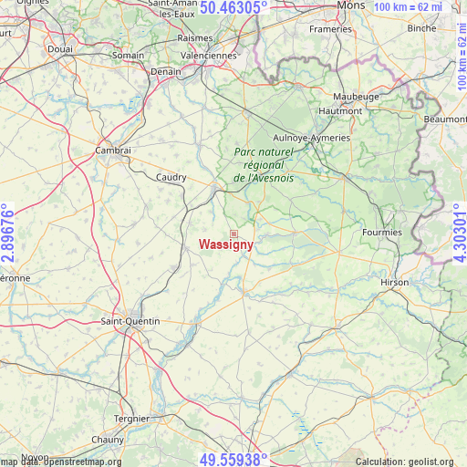
Wassigny GPS coordinates[2]
50° 0' 48.024" North, 3° 35' 59.568" East
| Map corner | latitude | longitude |
|---|---|---|
| Upper-left | 50.46305°, | 2.89676° |
| Center: | 50.01334°, | 3.59988° |
| Lower-right: | 49.55938°, | 4.30301° |
| Map W x H: | 100.5×100.5 km | = 62.4×62.4mi |
| max Lat: | 51.07786° ⇑6.3% North |
| Wassigny: | 50.01334° |
| min Lat: | ⇓93.7% South 41.3874° |
| min Long | Wassigny | max Long |
| -5.08615° | 3.59988° | 9.52242° |
| W 65%⇐ | ⇒35% E |
Elevation
Elevation of Wassigny is 160 m = 525 ft, and this is 33.7 m = 111 ft below average elevation for this country.
| Max E: |
2333 m = 7654 ft | 42.4% |
| Avg. | 193.7 m = 635 ft | |
| Wassigny | 160 m = 525 ft | |
Min E: |
-1 m = -3 ft | 57.6% |
See also: France elevation on elevation.city.
Geographical zone
Wassigny is located in North temperate zone (between Tropic of Cancer and the Arctic Circle). Distance of this North polar circle is 1840.2 km =1143.4 mi to North.| Distance of | km | miles | from Wassigny |
|---|---|---|---|
| North Pole | 4446.1 | 2762.7 | to North |
| Arctic Circle | 1840.2 | 1143.4 | to North |
| Tropic Cancer | 2955 | 1836.2 | to South |
| Equator | 5561 | 3455.4 | to South |


Nearby cities:
15 places around Wassigny: (largest is in red/bold)
• Bazuel
8.7 km =5.4 mi,  356°
356°
• Bohain-en-Vermandois
10.9 km =6.8 mi,  254°
254°
• Boué
6.9 km =4.3 mi,  91°
91°
• Busigny
9.8 km =6.1 mi,  283°
283°
• Catillon-sur-Sambre
7.3 km =4.5 mi,  24°
24°
• Esquéhéries
11 km =6.8 mi,  107°
107°
• Lesquielles-Saint-Germain
9.1 km =5.7 mi,  171°
171°
• Mennevret
4.4 km =2.7 mi,  226°
226°
• Ors
10 km =6.2 mi,  14°
14°
• Pommereuil
11 km =6.8 mi, 358°
• Saint-Souplet
6.8 km =4.2 mi,  314°
314°
• Seboncourt
11.1 km =6.9 mi, 232°
• Vadencourt
9.2 km =5.7 mi,  194°
194°
• Vaux-Andigny
6 km =3.7 mi, 280°
• Étreux
4.9 km =3 mi,  132°
132°
Sources, notices
• [Note1] Compared only with cities in France existing in our database
• [Src1] Map data: © OpenStreetMap contributors (CC-BY-SA)
• [Src2] Other city data from geonames.org with taken over terms of usage.
• [Src3] Geographical zone / Annual Mean Temperature by Robert A. Rohde @ Wikipedia
