Étreux geodata
Étreux (Hauts-de-France) is a populated place; located in France in Europe/Paris (GMT+2) time zone. With population of 1,645 people, there are 5680 cities with bigger population in this country. Compared to other cities in France, 93.5% of cities are located further ↓South; 65.4% of cities are located further ←West and 51.7% of cities have lower elevation than Étreux. Note1
Administrative division(s):
- Level 1: Hauts-de-France
- Level 2: Département de l'Aisne
- Level 3: Arrondissement de Vervins
- Level 4: Étreux


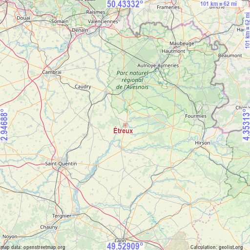
Étreux GPS coordinates[2]
49° 58' 59.988" North, 3° 39' 0" East
| Map corner | latitude | longitude |
|---|---|---|
| Upper-left | 50.43332°, | 2.94688° |
| Center: | 49.98333°, | 3.65° |
| Lower-right: | 49.52909°, | 4.35313° |
| Map W x H: | 100.5×100.5 km | = 62.4×62.4mi |
| max Lat: | 51.07786° ⇑6.5% North |
| Étreux: | 49.98333° |
| min Lat: | ⇓93.5% South 41.3874° |
| min Long | Étreux | max Long |
| -5.08615° | 3.65° | 9.52242° |
| W 65.4%⇐ | ⇒34.6% E |
Elevation
Elevation of Étreux is 138 m = 453 ft, and this is 55.7 m = 183 ft below average elevation for this country.
| Max E: |
2333 m = 7654 ft | 48.3% |
| Avg. | 193.7 m = 635 ft | |
| Étreux | 138 m = 453 ft | |
Min E: |
-1 m = -3 ft | 51.7% |
See also: France elevation on elevation.city.
Geographical zone
Étreux is located in North temperate zone (between Tropic of Cancer and the Arctic Circle). Distance of this North polar circle is 1843.5 km =1145.5 mi to North.| Distance of | km | miles | from Étreux |
|---|---|---|---|
| North Pole | 4449.4 | 2764.7 | to North |
| Arctic Circle | 1843.5 | 1145.5 | to North |
| Tropic Cancer | 2951.7 | 1834.1 | to South |
| Equator | 5557.6 | 3453.3 | to South |


Nearby cities:
15 places around Étreux: (largest is in red/bold)
• Bazuel
12.7 km =7.9 mi,  340°
340°
• Boué
4.5 km =2.8 mi,  46°
46°
• Buironfosse
13.4 km =8.3 mi,  97°
97°
• Catillon-sur-Sambre
10 km =6.2 mi,  356°
356°
• Esquéhéries
7 km =4.3 mi,  89°
89°
• Guise
9.3 km =5.8 mi,  189°
189°
• Le Nouvion-en-Thiérache
10.3 km =6.4 mi,  69°
69°
• Lesquielles-Saint-Germain
6.1 km =3.8 mi,  202°
202°
• Mennevret
6.8 km =4.2 mi,  272°
272°
• Ors
13.1 km =8.1 mi,  354°
354°
• Saint-Souplet
11.7 km =7.3 mi,  313°
313°
• Seboncourt
12.9 km =8 mi,  254°
254°
• Vadencourt
8.2 km =5.1 mi,  226°
226°
• Vaux-Andigny
10.5 km =6.5 mi,  294°
294°
• Wassigny
4.9 km =3 mi, 312°
Sources, notices
• [Note1] Compared only with cities in France existing in our database
• [Src1] Map data: © OpenStreetMap contributors (CC-BY-SA)
• [Src2] Other city data from geonames.org with taken over terms of usage.
• [Src3] Geographical zone / Annual Mean Temperature by Robert A. Rohde @ Wikipedia
