Mennevret geodata
Mennevret (Hauts-de-France) is a populated place; located in France in Europe/Paris (GMT+2) time zone. With population of 658 people, there are 12412 cities with bigger population in this country. Compared to other cities in France, 93.5% of cities are located further ↓South; 64.7% of cities are located further ←West and 60.5% of cities have lower elevation than Mennevret. Note1
Administrative division(s):
- Level 1: Hauts-de-France
- Level 2: Département de l'Aisne
- Level 3: Arrondissement de Vervins
- Level 4: Mennevret


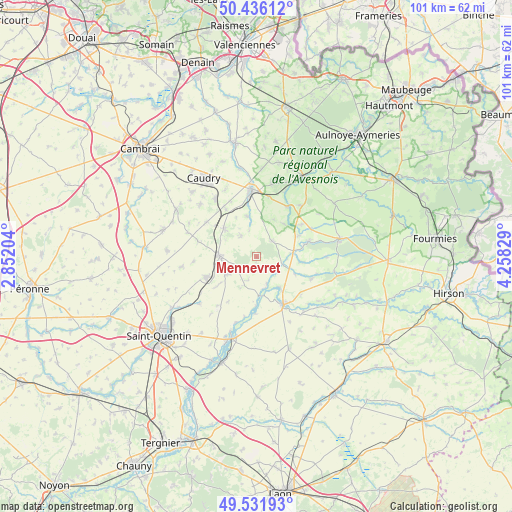
Mennevret GPS coordinates[2]
49° 59' 10.14" North, 3° 33' 18.576" East
| Map corner | latitude | longitude |
|---|---|---|
| Upper-left | 50.43612°, | 2.85204° |
| Center: | 49.98615°, | 3.55516° |
| Lower-right: | 49.53193°, | 4.25829° |
| Map W x H: | 100.5×100.5 km | = 62.4×62.4mi |
| max Lat: | 51.07786° ⇑6.5% North |
| Mennevret: | 49.98615° |
| min Lat: | ⇓93.5% South 41.3874° |
| min Long | Mennevret | max Long |
| -5.08615° | 3.55516° | 9.52242° |
| W 64.7%⇐ | ⇒35.3% E |
Elevation
Elevation of Mennevret is 172 m = 564 ft, and this is 21.7 m = 71 ft below average elevation for this country.
| Max E: |
2333 m = 7654 ft | 39.5% |
| Avg. | 193.7 m = 635 ft | |
| Mennevret | 172 m = 564 ft | |
Min E: |
-1 m = -3 ft | 60.5% |
See also: France elevation on elevation.city.
Geographical zone
Mennevret is located in North temperate zone (between Tropic of Cancer and the Arctic Circle). Distance of this North polar circle is 1843.2 km =1145.3 mi to North.| Distance of | km | miles | from Mennevret |
|---|---|---|---|
| North Pole | 4449.1 | 2764.5 | to North |
| Arctic Circle | 1843.2 | 1145.3 | to North |
| Tropic Cancer | 2952 | 1834.3 | to South |
| Equator | 5557.9 | 3453.5 | to South |


Nearby cities:
15 places around Mennevret: (largest is in red/bold)
• Bohain-en-Vermandois
7.3 km =4.5 mi,  271°
271°
• Boué
10.5 km =6.5 mi,  74°
74°
• Busigny
8.3 km =5.2 mi,  310°
310°
• Catillon-sur-Sambre
11.5 km =7.1 mi,  32°
32°
• Fresnoy-le-Grand
10.7 km =6.6 mi,  246°
246°
• Guise
10.9 km =6.8 mi,  151°
151°
• Honnechy
11 km =6.8 mi,  327°
327°
• Lesquielles-Saint-Germain
7.5 km =4.7 mi,  143°
143°
• Saint-Souplet
8 km =5 mi,  347°
347°
• Seboncourt
6.8 km =4.2 mi,  236°
236°
• Vadencourt
5.9 km =3.7 mi,  172°
172°
• Vaux-Andigny
4.9 km =3 mi, 326°
• Wassigny
4.4 km =2.7 mi,  46°
46°
• Étaves-et-Bocquiaux
8.8 km =5.5 mi,  233°
233°
• Étreux
6.8 km =4.2 mi,  92°
92°
Sources, notices
• [Note1] Compared only with cities in France existing in our database
• [Src1] Map data: © OpenStreetMap contributors (CC-BY-SA)
• [Src2] Other city data from geonames.org with taken over terms of usage.
• [Src3] Geographical zone / Annual Mean Temperature by Robert A. Rohde @ Wikipedia
