Erquy geodata
Erquy (Brittany) is a populated place; located in France in Europe/Paris (GMT+2) time zone. With population of 3,722 people, there are 2639 cities with bigger population in this country. Compared to other cities in France, 71.6% of cities are located further ↓South; 96.2% of cities are located further →East and 98.2% of cities have higher elevation than Erquy. Note1
Administrative division(s):
- Level 1: Brittany
- Level 2: Département des Côtes-d’Armor
- Level 3: Arrondissement de Saint-Brieuc
- Level 4: Erquy


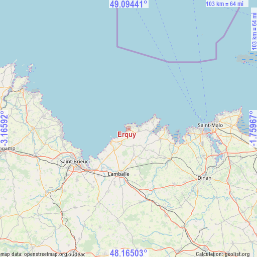
Erquy GPS coordinates[2]
48° 37' 54.696" North, 2° 27' 46.08" West
| Map corner | latitude | longitude |
|---|---|---|
| Upper-left | 49.09441°, | -3.16592° |
| Center: | 48.63186°, | -2.4628° |
| Lower-right: | 48.16503°, | -1.75967° |
| Map W x H: | 103.3×103.3 km | = 64.2×64.2mi |
| max Lat: | 51.07786° ⇑28.4% North |
| Erquy: | 48.63186° |
| min Lat: | ⇓71.6% South 41.3874° |
| min Long | Erquy | max Long |
| -5.08615° | -2.4628° | 9.52242° |
| W 3.8%⇐ | ⇒96.2% E |
Elevation
Elevation of Erquy is 8 m = 26 ft, and this is 185.7 m = 609 ft below average elevation for this country.
| Max E: |
2333 m = 7654 ft | 98.2% |
| Avg. | 193.7 m = 635 ft | |
| Erquy | 8 m = 26 ft | |
Min E: |
-1 m = -3 ft | 1.8% |
See also: France elevation on elevation.city.
Geographical zone
Erquy is located in North temperate zone (between Tropic of Cancer and the Arctic Circle). Distance of this North polar circle is 1993.8 km =1238.9 mi to North.| Distance of | km | miles | from Erquy |
|---|---|---|---|
| North Pole | 4599.7 | 2858.1 | to North |
| Arctic Circle | 1993.8 | 1238.9 | to North |
| Tropic Cancer | 2801.4 | 1740.7 | to South |
| Equator | 5407.4 | 3360 | to South |


Nearby cities:
15 places around Erquy: (largest is in red/bold)
• Andel
17.5 km =10.9 mi,  205°
205°
• Fréhel
7.1 km =4.4 mi,  88°
88°
• Hénanbihen
10.2 km =6.3 mi,  141°
141°
• Hénansal
10.4 km =6.5 mi,  168°
168°
• La Bouillie
6.8 km =4.2 mi,  162°
162°
• Matignon
13.2 km =8.2 mi,  107°
107°
• Morieux
16.3 km =10.1 mi,  221°
221°
• Planguenoual
13.8 km =8.6 mi, 217°
• Plurien
4.4 km =2.7 mi,  99°
99°
• Pléboulle
9.5 km =5.9 mi, 105°
• Pléneuf-Val-André
7.5 km =4.7 mi,  235°
235°
• Ruca
11.6 km =7.2 mi,  128°
128°
• Saint-Alban
10.1 km =6.3 mi, 214°
• Saint-Cast-le-Guildo
15.1 km =9.4 mi, 90°
• Saint-Pôtan
16 km =9.9 mi,  124°
124°
Sources, notices
• [Note1] Compared only with cities in France existing in our database
• [Src1] Map data: © OpenStreetMap contributors (CC-BY-SA)
• [Src2] Other city data from geonames.org with taken over terms of usage.
• [Src3] Geographical zone / Annual Mean Temperature by Robert A. Rohde @ Wikipedia
