Ercé geodata
Ercé (Occitanie) is a populated place; located in France in Europe/Paris (GMT+2) time zone. With population of 538 people, there are 14429 cities with bigger population in this country. Compared to other cities in France, 98.7% of cities are located further ↑North; 65.7% of cities are located further →East and 95.6% of cities have lower elevation than Ercé. Note1
Administrative division(s):
- Level 1: Occitanie
- Level 2: Département de l'Ariège
- Level 3: Arrondissement de Saint-Girons
- Level 4: Ercé


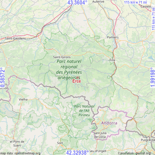
Ercé GPS coordinates[2]
42° 50' 49.344" North, 1° 17' 19.86" East
| Map corner | latitude | longitude |
|---|---|---|
| Upper-left | 43.3604°, | 0.58572° |
| Center: | 42.84704°, | 1.28885° |
| Lower-right: | 42.32938°, | 1.99198° |
| Map W x H: | 114.6×114.6 km | = 71.2×71.2mi |
| max Lat: | 51.07786° ⇑98.7% North |
| Ercé: | 42.84704° |
| min Lat: | ⇓1.3% South 41.3874° |
| min Long | Ercé | max Long |
| -5.08615° | 1.28885° | 9.52242° |
| W 34.3%⇐ | ⇒65.7% E |
Elevation
Elevation of Ercé is 617 m = 2024 ft, and this is 423.3 m = 1389 ft above average elevation for this country.
| Max E: |
2333 m = 7654 ft | 4.4% |
| Ercé | 617 m 2024 ft | |
| Avg. | 193.7 m = 635 ft | |
Min E: |
-1 m = -3 ft | 95.6% |
See also: France elevation on elevation.city.
Geographical zone
Ercé is located in North temperate zone (between Tropic of Cancer and the Arctic Circle). Distance of this Northern Tropic circle is 2158.2 km =1341 mi to South.| Distance of | km | miles | from Ercé |
|---|---|---|---|
| North Pole | 5242.9 | 3257.8 | to North |
| Arctic Circle | 2637 | 1638.6 | to North |
| Tropic Cancer | 2158.2 | 1341 | to South |
| Equator | 4764.1 | 2960.3 | to South |


Nearby cities:
15 places around Ercé: (largest is in red/bold)
• Auzat
18.1 km =11.2 mi,  120°
120°
• Brassac
23 km =14.3 mi,  61°
61°
• Eycheil
16.9 km =10.5 mi,  322°
322°
• La Bastide-de-Sérou
21.6 km =13.4 mi,  31°
31°
• Massat
6.6 km =4.1 mi,  45°
45°
• Montjoie-en-Couserans
20.2 km =12.6 mi,  328°
328°
• Moulis
20.5 km =12.7 mi,  308°
308°
• Oust
6.7 km =4.2 mi,  297°
297°
• Rimont
16.5 km =10.3 mi,  358°
358°
• Saint-Girons
19.2 km =11.9 mi, 322°
• Saint-Lizier
21.2 km =13.2 mi, 324°
• Saurat
20.6 km =12.8 mi,  80°
80°
• Seix
7.4 km =4.6 mi,  284°
284°
• Serres-sur-Arget
22.9 km =14.2 mi, 53°
• Vicdessos
18.9 km =11.7 mi, 117°
Sources, notices
• [Note1] Compared only with cities in France existing in our database
• [Src1] Map data: © OpenStreetMap contributors (CC-BY-SA)
• [Src2] Other city data from geonames.org with taken over terms of usage.
• [Src3] Geographical zone / Annual Mean Temperature by Robert A. Rohde @ Wikipedia
