Saint-Girons geodata
Saint-Girons (Occitanie) is a seat of a third-order administrative division; located in France in Europe/Paris (GMT+2) time zone. With population of 7,004 people, there are 1399 cities with bigger population in this country. Compared to other cities in France, 98.4% of cities are located further ↑North; 67.4% of cities are located further →East and 91% of cities have lower elevation than Saint-Girons. Note1
Administrative division(s):
- Level 1: Occitanie
- Level 2: Département de l'Ariège
- Level 3: Arrondissement de Saint-Girons
- Level 4: Saint-Girons


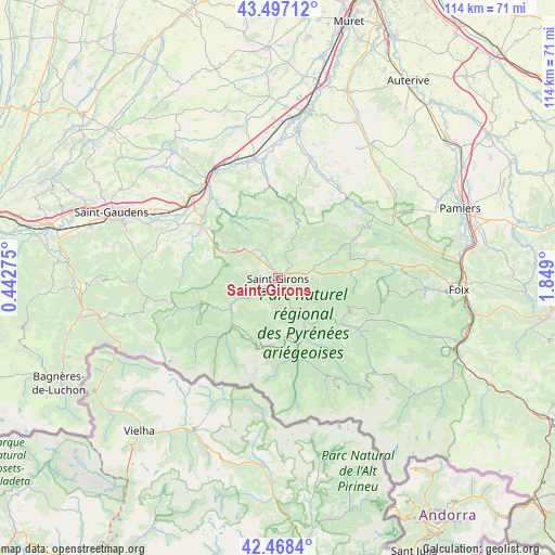
Saint-Girons GPS coordinates[2]
42° 59' 5.676" North, 1° 8' 45.132" East
| Map corner | latitude | longitude |
|---|---|---|
| Upper-left | 43.49712°, | 0.44275° |
| Center: | 42.98491°, | 1.14587° |
| Lower-right: | 42.4684°, | 1.849° |
| Map W x H: | 114.4×114.4 km | = 71.1×71.1mi |
| max Lat: | 51.07786° ⇑98.4% North |
| Saint-Girons: | 42.98491° |
| min Lat: | ⇓1.6% South 41.3874° |
| min Long | Saint-Girons | max Long |
| -5.08615° | 1.14587° | 9.52242° |
| W 32.6%⇐ | ⇒67.4% E |
Elevation
Elevation of Saint-Girons is 449 m = 1473 ft, and this is 255.3 m = 838 ft above average elevation for this country.
| Max E: |
2333 m = 7654 ft | 9% |
| Saint-Girons | 449 m 1473 ft | |
| Avg. | 193.7 m = 635 ft | |
Min E: |
-1 m = -3 ft | 91% |
See also: France elevation on elevation.city.
Geographical zone
Saint-Girons is located in North temperate zone (between Tropic of Cancer and the Arctic Circle). Distance of this Northern Tropic circle is 2173.6 km =1350.6 mi to South.| Distance of | km | miles | from Saint-Girons |
|---|---|---|---|
| North Pole | 5227.6 | 3248.3 | to North |
| Arctic Circle | 2621.7 | 1629 | to North |
| Tropic Cancer | 2173.6 | 1350.6 | to South |
| Equator | 4779.5 | 2969.8 | to South |


Nearby cities:
15 places around Saint-Girons: (largest is in red/bold)
• Cassagne
19.8 km =12.3 mi,  320°
320°
• Daumazan-sur-Arize
21.9 km =13.6 mi,  36°
36°
• Ercé
19.2 km =11.9 mi,  142°
142°
• Eycheil
2.3 km =1.4 mi, 141°
• Mane
19.1 km =11.9 mi,  304°
304°
• Massat
19.6 km =12.2 mi,  123°
123°
• Montjoie-en-Couserans
2.3 km =1.4 mi,  30°
30°
• Moulis
5.1 km =3.2 mi,  239°
239°
• Oust
13.5 km =8.4 mi,  155°
155°
• Prat-Bonrepaux
11.8 km =7.3 mi, 297°
• Rimont
11.2 km =7 mi,  84°
84°
• Saint-Lizier
2 km =1.2 mi,  338°
338°
• Sainte-Croix-Volvestre
16.6 km =10.3 mi,  5°
5°
• Salies-du-Salat
19.9 km =12.4 mi,  310°
310°
• Seix
14.2 km =8.8 mi, 161°
Sources, notices
• [Note1] Compared only with cities in France existing in our database
• [Src1] Map data: © OpenStreetMap contributors (CC-BY-SA)
• [Src2] Other city data from geonames.org with taken over terms of usage.
• [Src3] Geographical zone / Annual Mean Temperature by Robert A. Rohde @ Wikipedia
