Émancé geodata
Émancé (Île-de-France) is a populated place; located in France in Europe/Paris (GMT+2) time zone. With population of 798 people, there are 10635 cities with bigger population in this country. Compared to other cities in France, 70.6% of cities are located further ↓South; 60.1% of cities are located further →East and 50.8% of cities have lower elevation than Émancé. Note1
Administrative division(s):
- Level 1: Île-de-France
- Level 2: Yvelines
- Level 3: Arrondissement de Rambouillet
- Level 4: Émancé


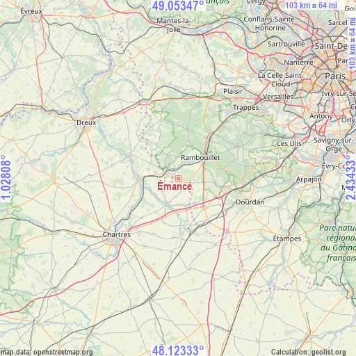
Émancé GPS coordinates[2]
48° 35' 25.944" North, 1° 43' 52.32" East
| Map corner | latitude | longitude |
|---|---|---|
| Upper-left | 49.05347°, | 1.02808° |
| Center: | 48.59054°, | 1.7312° |
| Lower-right: | 48.12333°, | 2.43433° |
| Map W x H: | 103.4×103.4 km | = 64.2×64.2mi |
| max Lat: | 51.07786° ⇑29.4% North |
| Émancé: | 48.59054° |
| min Lat: | ⇓70.6% South 41.3874° |
| min Long | Émancé | max Long |
| -5.08615° | 1.7312° | 9.52242° |
| W 39.9%⇐ | ⇒60.1% E |
Elevation
Elevation of Émancé is 135 m = 443 ft, and this is 58.7 m = 193 ft below average elevation for this country.
| Max E: |
2333 m = 7654 ft | 49.2% |
| Avg. | 193.7 m = 635 ft | |
| Émancé | 135 m = 443 ft | |
Min E: |
-1 m = -3 ft | 50.8% |
See also: France elevation on elevation.city.
Geographical zone
Émancé is located in North temperate zone (between Tropic of Cancer and the Arctic Circle). Distance of this North polar circle is 1998.4 km =1241.7 mi to North.| Distance of | km | miles | from Émancé |
|---|---|---|---|
| North Pole | 4604.3 | 2861 | to North |
| Arctic Circle | 1998.4 | 1241.7 | to North |
| Tropic Cancer | 2796.8 | 1737.9 | to South |
| Equator | 5402.8 | 3357.1 | to South |


Nearby cities:
15 places around Émancé: (largest is in red/bold)
• Armenonville-les-Gâtineaux
8.1 km =5 mi,  229°
229°
• Droue-sur-Drouette
2.5 km =1.6 mi,  296°
296°
• Gallardon
7.7 km =4.8 mi,  201°
201°
• Gas
5.4 km =3.4 mi,  240°
240°
• Gazeran
5.5 km =3.4 mi,  32°
32°
• Hanches
6 km =3.7 mi,  281°
281°
• Houx
8.7 km =5.4 mi,  252°
252°
• Orcemont
5.8 km =3.6 mi,  92°
92°
• Orphin
3.9 km =2.4 mi,  110°
110°
• Raizeux
5.2 km =3.2 mi,  317°
317°
• Saint-Hilarion
3.3 km =2.1 mi,  3°
3°
• Saint-Symphorien-le-Château
8.4 km =5.2 mi,  164°
164°
• Yermenonville
9 km =5.6 mi, 245°
• Écrosnes
4.9 km =3 mi,  181°
181°
• Épernon
4.9 km =3 mi, 296°
Sources, notices
• [Note1] Compared only with cities in France existing in our database
• [Src1] Map data: © OpenStreetMap contributors (CC-BY-SA)
• [Src2] Other city data from geonames.org with taken over terms of usage.
• [Src3] Geographical zone / Annual Mean Temperature by Robert A. Rohde @ Wikipedia
