Elven geodata
Elven (Brittany) is a populated place; located in France in Europe/Paris (GMT+2) time zone. With population of 3,824 people, there are 2576 cities with bigger population in this country. Compared to other cities in France, 54.7% of cities are located further ↓South; 96.4% of cities are located further →East and 66.6% of cities have higher elevation than Elven. Note1
Administrative division(s):
- Level 1: Brittany
- Level 2: Morbihan
- Level 3: Arrondissement de Vannes
- Level 4: Elven


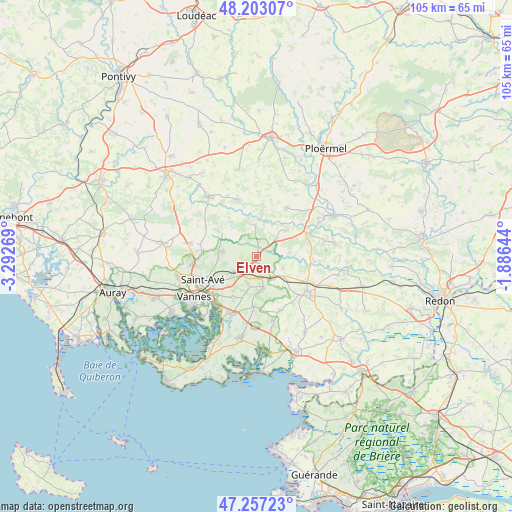
Elven GPS coordinates[2]
47° 43' 56.28" North, 2° 35' 22.416" West
| Map corner | latitude | longitude |
|---|---|---|
| Upper-left | 48.20307°, | -3.29269° |
| Center: | 47.7323°, | -2.58956° |
| Lower-right: | 47.25723°, | -1.88644° |
| Map W x H: | 105.2×105.2 km | = 65.4×65.4mi |
| max Lat: | 51.07786° ⇑45.3% North |
| Elven: | 47.7323° |
| min Lat: | ⇓54.7% South 41.3874° |
| min Long | Elven | max Long |
| -5.08615° | -2.58956° | 9.52242° |
| W 3.6%⇐ | ⇒96.4% E |
Elevation
Elevation of Elven is 86 m = 282 ft, and this is 107.7 m = 353 ft below average elevation for this country.
| Max E: |
2333 m = 7654 ft | 66.6% |
| Avg. | 193.7 m = 635 ft | |
| Elven | 86 m = 282 ft | |
Min E: |
-1 m = -3 ft | 33.4% |
See also: France elevation on elevation.city.
Geographical zone
Elven is located in North temperate zone (between Tropic of Cancer and the Arctic Circle). Distance of this North polar circle is 2093.8 km =1301 mi to North.| Distance of | km | miles | from Elven |
|---|---|---|---|
| North Pole | 4699.7 | 2920.3 | to North |
| Arctic Circle | 2093.8 | 1301 | to North |
| Tropic Cancer | 2701.4 | 1678.6 | to South |
| Equator | 5307.3 | 3297.8 | to South |


Nearby cities:
15 places around Elven: (largest is in red/bold)
• Berric
12.1 km =7.5 mi,  155°
155°
• Bohal
12.5 km =7.8 mi,  64°
64°
• La Vraie-Croix
5.9 km =3.7 mi,  143°
143°
• Larré
6 km =3.7 mi,  111°
111°
• Molac
11.6 km =7.2 mi,  91°
91°
• Monterblanc
6.8 km =4.2 mi,  279°
279°
• Plaudren
9.3 km =5.8 mi,  303°
303°
• Plumelec
12.3 km =7.6 mi,  342°
342°
• Saint-Guyomard
7.8 km =4.8 mi,  46°
46°
• Saint-Nolff
5.7 km =3.5 mi,  235°
235°
• Sulniac
6.7 km =4.2 mi,  168°
168°
• Sérent
11.9 km =7.4 mi,  31°
31°
• Theix
12.4 km =7.7 mi,  202°
202°
• Treffléan
5.9 km =3.7 mi, 197°
• Trédion
6.6 km =4.1 mi,  358°
358°
Sources, notices
• [Note1] Compared only with cities in France existing in our database
• [Src1] Map data: © OpenStreetMap contributors (CC-BY-SA)
• [Src2] Other city data from geonames.org with taken over terms of usage.
• [Src3] Geographical zone / Annual Mean Temperature by Robert A. Rohde @ Wikipedia
