Plumelec geodata
Plumelec (Brittany) is a populated place; located in France in Europe/Paris (GMT+2) time zone. With population of 2,553 people, there are 3820 cities with bigger population in this country. Compared to other cities in France, 56.4% of cities are located further ↓South; 96.5% of cities are located further →East and 56.3% of cities have lower elevation than Plumelec. Note1
Administrative division(s):
- Level 1: Brittany
- Level 2: Morbihan
- Level 3: Arrondissement de Pontivy
- Level 4: Plumelec


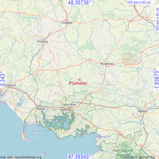
Plumelec GPS coordinates[2]
47° 50' 15.144" North, 2° 38' 23.532" West
| Map corner | latitude | longitude |
|---|---|---|
| Upper-left | 48.30736°, | -3.343° |
| Center: | 47.83754°, | -2.63987° |
| Lower-right: | 47.36343°, | -1.93675° |
| Map W x H: | 105×105 km | = 65.2×65.2mi |
| max Lat: | 51.07786° ⇑43.6% North |
| Plumelec: | 47.83754° |
| min Lat: | ⇓56.4% South 41.3874° |
| min Long | Plumelec | max Long |
| -5.08615° | -2.63987° | 9.52242° |
| W 3.5%⇐ | ⇒96.5% E |
Elevation
Elevation of Plumelec is 155 m = 509 ft, and this is 38.7 m = 127 ft below average elevation for this country.
| Max E: |
2333 m = 7654 ft | 43.7% |
| Avg. | 193.7 m = 635 ft | |
| Plumelec | 155 m = 509 ft | |
Min E: |
-1 m = -3 ft | 56.3% |
See also: France elevation on elevation.city.
Geographical zone
Plumelec is located in North temperate zone (between Tropic of Cancer and the Arctic Circle). Distance of this North polar circle is 2082.1 km =1293.8 mi to North.| Distance of | km | miles | from Plumelec |
|---|---|---|---|
| North Pole | 4688 | 2913 | to North |
| Arctic Circle | 2082.1 | 1293.8 | to North |
| Tropic Cancer | 2713.1 | 1685.8 | to South |
| Equator | 5319 | 3305.1 | to South |


Nearby cities:
15 places around Plumelec: (largest is in red/bold)
• Bignan
10.9 km =6.8 mi,  295°
295°
• Colpo
12.9 km =8 mi,  260°
260°
• Cruguel
5.6 km =3.5 mi,  36°
36°
• Elven
12.3 km =7.6 mi,  162°
162°
• Guégon
12.4 km =7.7 mi,  26°
26°
• Guéhenno
6.1 km =3.8 mi,  359°
359°
• Lizio
9 km =5.6 mi,  71°
71°
• Locmaria-Grand-Champ
14.1 km =8.8 mi,  230°
230°
• Monterblanc
11 km =6.8 mi,  195°
195°
• Plaudren
7.7 km =4.8 mi,  211°
211°
• Saint-Guyomard
11.3 km =7 mi,  123°
123°
• Saint-Jean-Brévelay
6.2 km =3.9 mi,  277°
277°
• Saint-Servant
12.9 km =8 mi,  47°
47°
• Sérent
10.1 km =6.3 mi,  98°
98°
• Trédion
6.2 km =3.9 mi,  145°
145°
Sources, notices
• [Note1] Compared only with cities in France existing in our database
• [Src1] Map data: © OpenStreetMap contributors (CC-BY-SA)
• [Src2] Other city data from geonames.org with taken over terms of usage.
• [Src3] Geographical zone / Annual Mean Temperature by Robert A. Rohde @ Wikipedia
