Lagardelle-sur-Lèze geodata
Lagardelle-sur-Lèze (Occitanie) is a populated place; located in France in Europe/Paris (GMT+2) time zone. With population of 2,447 people, there are 3959 cities with bigger population in this country. Compared to other cities in France, 94.1% of cities are located further ↑North; 64.4% of cities are located further →East and 64.4% of cities have lower elevation than Lagardelle-sur-Lèze. Note1
Administrative division(s):
- Level 1: Occitanie
- Level 2: Haute-Garonne
- Level 3: Arrondissement de Muret
- Level 4: Lagardelle-sur-Lèze


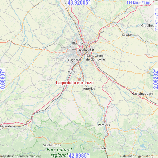
Lagardelle-sur-Lèze GPS coordinates[2]
43° 24' 41.148" North, 1° 23' 21.12" East
| Map corner | latitude | longitude |
|---|---|---|
| Upper-left | 43.92005°, | 0.68607° |
| Center: | 43.41143°, | 1.3892° |
| Lower-right: | 42.8985°, | 2.09232° |
| Map W x H: | 113.6×113.6 km | = 70.6×70.6mi |
| max Lat: | 51.07786° ⇑94.1% North |
| Lagardelle-sur-Lèze: | 43.41143° |
| min Lat: | ⇓5.9% South 41.3874° |
| min Long | Lagardelle-sur- | max Long |
| -5.08615° | 1.3892° | 9.52242° |
| W 35.6%⇐ | ⇒64.4% E |
Elevation
Elevation of Lagardelle-sur-Lèze is 191 m = 627 ft, and this is 2.7 m = 9 ft below average elevation for this country.
| Max E: |
2333 m = 7654 ft | 35.6% |
| Avg. | 193.7 m = 635 ft | |
| Lagardelle-sur-Lèze | 191 m = 627 ft | |
Min E: |
-1 m = -3 ft | 64.4% |
See also: France elevation on elevation.city.
Geographical zone
Lagardelle-sur-Lèze is located in North temperate zone (between Tropic of Cancer and the Arctic Circle). Distance of this Northern Tropic circle is 2221 km =1380.1 mi to South.| Distance of | km | miles | from Lagardelle-sur-Lèze |
|---|---|---|---|
| North Pole | 5180.2 | 3218.8 | to North |
| Arctic Circle | 2574.3 | 1599.6 | to North |
| Tropic Cancer | 2221 | 1380.1 | to South |
| Equator | 4826.9 | 2999.3 | to South |


Nearby cities:
15 places around Lagardelle-sur-Lèze: (largest is in red/bold)
• Aureville
9.3 km =5.8 mi,  33°
33°
• Beaumont-sur-Lèze
4.2 km =2.6 mi,  216°
216°
• Clermont-le-Fort
5.5 km =3.4 mi, 26°
• Eaunes
3 km =1.9 mi,  290°
290°
• Goyrans
8.6 km =5.3 mi,  22°
22°
• Grépiac
4.8 km =3 mi,  99°
99°
• Labarthe-sur-Lèze
4.6 km =2.9 mi,  10°
10°
• Le Fauga
7.7 km =4.8 mi,  257°
257°
• Mauzac
8.8 km =5.5 mi,  242°
242°
• Miremont
5.1 km =3.2 mi,  153°
153°
• Muret
7.5 km =4.7 mi,  316°
316°
• Saint-Hilaire
9.1 km =5.7 mi,  277°
277°
• Saubens
8.2 km =5.1 mi,  338°
338°
• Venerque
5.3 km =3.3 mi,  60°
60°
• Vernet
3.3 km =2.1 mi,  42°
42°
Sources, notices
• [Note1] Compared only with cities in France existing in our database
• [Src1] Map data: © OpenStreetMap contributors (CC-BY-SA)
• [Src2] Other city data from geonames.org with taken over terms of usage.
• [Src3] Geographical zone / Annual Mean Temperature by Robert A. Rohde @ Wikipedia
