Labarthe-sur-Lèze geodata
Labarthe-sur-Lèze (Occitanie) is a populated place; located in France in Europe/Paris (GMT+2) time zone. With population of 5,208 people, there are 1891 cities with bigger population in this country. Compared to other cities in France, 93.7% of cities are located further ↑North; 64.3% of cities are located further →East and 60% of cities have lower elevation than Labarthe-sur-Lèze. Note1
Administrative division(s):
- Level 1: Occitanie
- Level 2: Haute-Garonne
- Level 3: Arrondissement de Muret
- Level 4: Labarthe-sur-Lèze


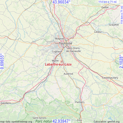
Labarthe-sur-Lèze GPS coordinates[2]
43° 27' 7.416" North, 1° 23' 58.848" East
| Map corner | latitude | longitude |
|---|---|---|
| Upper-left | 43.96034°, | 0.69655° |
| Center: | 43.45206°, | 1.39968° |
| Lower-right: | 42.93947°, | 2.1028° |
| Map W x H: | 113.5×113.5 km | = 70.5×70.5mi |
| max Lat: | 51.07786° ⇑93.7% North |
| Labarthe-sur-Lèze: | 43.45206° |
| min Lat: | ⇓6.3% South 41.3874° |
| min Long | Labarthe-sur-L� | max Long |
| -5.08615° | 1.39968° | 9.52242° |
| W 35.7%⇐ | ⇒64.3% E |
Elevation
Elevation of Labarthe-sur-Lèze is 170 m = 558 ft, and this is 23.7 m = 78 ft below average elevation for this country.
| Max E: |
2333 m = 7654 ft | 40% |
| Avg. | 193.7 m = 635 ft | |
| Labarthe-sur-Lèze | 170 m = 558 ft | |
Min E: |
-1 m = -3 ft | 60% |
See also: France elevation on elevation.city.
Geographical zone
Labarthe-sur-Lèze is located in North temperate zone (between Tropic of Cancer and the Arctic Circle). Distance of this Northern Tropic circle is 2225.5 km =1382.9 mi to South.| Distance of | km | miles | from Labarthe-sur-Lèze |
|---|---|---|---|
| North Pole | 5175.6 | 3216 | to North |
| Arctic Circle | 2569.8 | 1596.8 | to North |
| Tropic Cancer | 2225.5 | 1382.9 | to South |
| Equator | 4831.4 | 3002.1 | to South |


Nearby cities:
15 places around Labarthe-sur-Lèze: (largest is in red/bold)
• Aureville
5.3 km =3.3 mi,  52°
52°
• Clermont-le-Fort
1.7 km =1.1 mi,  77°
77°
• Eaunes
5.1 km =3.2 mi,  226°
226°
• Goyrans
4.2 km =2.6 mi,  36°
36°
• Grépiac
6.5 km =4 mi,  143°
143°
• Lacroix-Falgarde
5.4 km =3.4 mi,  8°
8°
• Lagardelle-sur-Lèze
4.6 km =2.9 mi,  190°
190°
• Muret
6 km =3.7 mi,  278°
278°
• Pinsaguel
6.6 km =4.1 mi,  351°
351°
• Portet-sur-Garonne
7.9 km =4.9 mi,  3°
3°
• Roquettes
5.6 km =3.5 mi,  333°
333°
• Saubens
4.9 km =3 mi,  308°
308°
• Venerque
4.2 km =2.6 mi,  117°
117°
• Vernet
2.5 km =1.6 mi,  146°
146°
• Vigoulet-Auzil
7.8 km =4.8 mi, 38°
Sources, notices
• [Note1] Compared only with cities in France existing in our database
• [Src1] Map data: © OpenStreetMap contributors (CC-BY-SA)
• [Src2] Other city data from geonames.org with taken over terms of usage.
• [Src3] Geographical zone / Annual Mean Temperature by Robert A. Rohde @ Wikipedia
