Grépiac geodata
Grépiac (Occitanie) is a populated place; located in France in Europe/Paris (GMT+2) time zone. With population of 887 people, there are 9762 cities with bigger population in this country. Compared to other cities in France, 94.2% of cities are located further ↑North; 63.7% of cities are located further →East and 63.3% of cities have lower elevation than Grépiac. Note1
Administrative division(s):
- Level 1: Occitanie
- Level 2: Haute-Garonne
- Level 3: Arrondissement de Muret
- Level 4: Grépiac


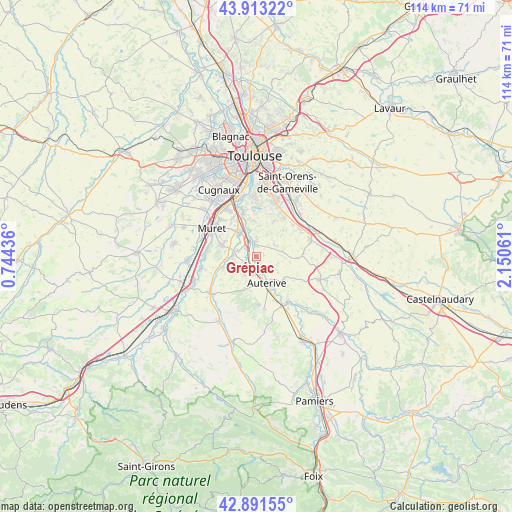
Grépiac GPS coordinates[2]
43° 24' 16.344" North, 1° 26' 50.964" East
| Map corner | latitude | longitude |
|---|---|---|
| Upper-left | 43.91322°, | 0.74436° |
| Center: | 43.40454°, | 1.44749° |
| Lower-right: | 42.89155°, | 2.15061° |
| Map W x H: | 113.6×113.6 km | = 70.6×70.6mi |
| max Lat: | 51.07786° ⇑94.2% North |
| Grépiac: | 43.40454° |
| min Lat: | ⇓5.8% South 41.3874° |
| min Long | Grépiac | max Long |
| -5.08615° | 1.44749° | 9.52242° |
| W 36.3%⇐ | ⇒63.7% E |
Elevation
Elevation of Grépiac is 186 m = 610 ft, and this is 7.7 m = 25 ft below average elevation for this country.
| Max E: |
2333 m = 7654 ft | 36.7% |
| Avg. | 193.7 m = 635 ft | |
| Grépiac | 186 m = 610 ft | |
Min E: |
-1 m = -3 ft | 63.3% |
See also: France elevation on elevation.city.
Geographical zone
Grépiac is located in North temperate zone (between Tropic of Cancer and the Arctic Circle). Distance of this Northern Tropic circle is 2220.2 km =1379.6 mi to South.| Distance of | km | miles | from Grépiac |
|---|---|---|---|
| North Pole | 5180.9 | 3219.3 | to North |
| Arctic Circle | 2575 | 1600 | to North |
| Tropic Cancer | 2220.2 | 1379.6 | to South |
| Equator | 4826.1 | 2998.8 | to South |


Nearby cities:
15 places around Grépiac: (largest is in red/bold)
• Aureville
8.6 km =5.3 mi,  2°
2°
• Auterive
6.4 km =4 mi,  157°
157°
• Beaumont-sur-Lèze
7.7 km =4.8 mi,  250°
250°
• Clermont-le-Fort
6.1 km =3.8 mi,  338°
338°
• Corronsac
8.7 km =5.4 mi,  27°
27°
• Deyme
10.7 km =6.6 mi,  36°
36°
• Eaunes
7.8 km =4.8 mi,  283°
283°
• Goyrans
8.8 km =5.5 mi,  351°
351°
• Labarthe-sur-Lèze
6.5 km =4 mi,  323°
323°
• Lagardelle-sur-Lèze
4.8 km =3 mi, 279°
• Miremont
4.6 km =2.9 mi,  212°
212°
• Montbrun-Lauragais
8.3 km =5.2 mi,  45°
45°
• Saint-Léon
9.1 km =5.7 mi,  92°
92°
• Venerque
3.3 km =2.1 mi,  357°
357°
• Vernet
4.1 km =2.5 mi, 322°
Sources, notices
• [Note1] Compared only with cities in France existing in our database
• [Src1] Map data: © OpenStreetMap contributors (CC-BY-SA)
• [Src2] Other city data from geonames.org with taken over terms of usage.
• [Src3] Geographical zone / Annual Mean Temperature by Robert A. Rohde @ Wikipedia
