Clermont-le-Fort geodata
Clermont-le-Fort (Occitanie) is a populated place; located in France in Europe/Paris (GMT+2) time zone. With population of 523 people, there are 14759 cities with bigger population in this country. Compared to other cities in France, 93.6% of cities are located further ↑North; 64% of cities are located further →East and 57.6% of cities have lower elevation than Clermont-le-Fort. Note1
Administrative division(s):
- Level 1: Occitanie
- Level 2: Haute-Garonne
- Level 3: Arrondissement de Toulouse
- Level 4: Clermont-le-Fort


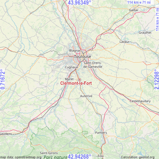
Clermont-le-Fort GPS coordinates[2]
43° 27' 18.864" North, 1° 25' 11.46" East
| Map corner | latitude | longitude |
|---|---|---|
| Upper-left | 43.96349°, | 0.71672° |
| Center: | 43.45524°, | 1.41985° |
| Lower-right: | 42.94268°, | 2.12298° |
| Map W x H: | 113.5×113.5 km | = 70.5×70.5mi |
| max Lat: | 51.07786° ⇑93.6% North |
| Clermont-le-Fort: | 43.45524° |
| min Lat: | ⇓6.4% South 41.3874° |
| min Long | Clermont-le-For | max Long |
| -5.08615° | 1.41985° | 9.52242° |
| W 36%⇐ | ⇒64% E |
Elevation
Elevation of Clermont-le-Fort is 160 m = 525 ft, and this is 33.7 m = 111 ft below average elevation for this country.
| Max E: |
2333 m = 7654 ft | 42.4% |
| Avg. | 193.7 m = 635 ft | |
| Clermont-le-Fort | 160 m = 525 ft | |
Min E: |
-1 m = -3 ft | 57.6% |
See also: France elevation on elevation.city.
Geographical zone
Clermont-le-Fort is located in North temperate zone (between Tropic of Cancer and the Arctic Circle). Distance of this Northern Tropic circle is 2225.9 km =1383.1 mi to South.| Distance of | km | miles | from Clermont-le-Fort |
|---|---|---|---|
| North Pole | 5175.3 | 3215.8 | to North |
| Arctic Circle | 2569.4 | 1596.6 | to North |
| Tropic Cancer | 2225.9 | 1383.1 | to South |
| Equator | 4831.8 | 3002.3 | to South |


Nearby cities:
15 places around Clermont-le-Fort: (largest is in red/bold)
• Aureville
3.9 km =2.4 mi,  41°
41°
• Corronsac
6.6 km =4.1 mi,  71°
71°
• Eaunes
6.6 km =4.1 mi,  234°
234°
• Goyrans
3.2 km =2 mi,  15°
15°
• Grépiac
6.1 km =3.8 mi,  158°
158°
• Labarthe-sur-Lèze
1.7 km =1.1 mi,  257°
257°
• Lacroix-Falgarde
5 km =3.1 mi,  350°
350°
• Lagardelle-sur-Lèze
5.5 km =3.4 mi,  206°
206°
• Muret
7.6 km =4.7 mi,  274°
274°
• Pinsaguel
6.6 km =4.1 mi,  337°
337°
• Roquettes
6.3 km =3.9 mi,  318°
318°
• Saubens
6.1 km =3.8 mi,  296°
296°
• Venerque
3.1 km =1.9 mi,  137°
137°
• Vernet
2.4 km =1.5 mi,  186°
186°
• Vigoulet-Auzil
6.6 km =4.1 mi,  29°
29°
Sources, notices
• [Note1] Compared only with cities in France existing in our database
• [Src1] Map data: © OpenStreetMap contributors (CC-BY-SA)
• [Src2] Other city data from geonames.org with taken over terms of usage.
• [Src3] Geographical zone / Annual Mean Temperature by Robert A. Rohde @ Wikipedia
