Orphin geodata
Orphin (Île-de-France) is a populated place; located in France in Europe/Paris (GMT+2) time zone. With population of 976 people, there are 9012 cities with bigger population in this country. Compared to other cities in France, 70.3% of cities are located further ↓South; 59.6% of cities are located further →East and 57.4% of cities have lower elevation than Orphin. Note1
Administrative division(s):
- Level 1: Île-de-France
- Level 2: Yvelines
- Level 3: Arrondissement de Rambouillet
- Level 4: Orphin


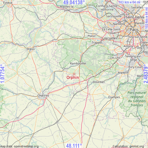
Orphin GPS coordinates[2]
48° 34' 41.988" North, 1° 46' 50.412" East
| Map corner | latitude | longitude |
|---|---|---|
| Upper-left | 49.04138°, | 1.07754° |
| Center: | 48.57833°, | 1.78067° |
| Lower-right: | 48.111°, | 2.48379° |
| Map W x H: | 103.4×103.4 km | = 64.2×64.2mi |
| max Lat: | 51.07786° ⇑29.7% North |
| Orphin: | 48.57833° |
| min Lat: | ⇓70.3% South 41.3874° |
| min Long | Orphin | max Long |
| -5.08615° | 1.78067° | 9.52242° |
| W 40.4%⇐ | ⇒59.6% E |
Elevation
Elevation of Orphin is 159 m = 522 ft, and this is 34.7 m = 114 ft below average elevation for this country.
| Max E: |
2333 m = 7654 ft | 42.6% |
| Avg. | 193.7 m = 635 ft | |
| Orphin | 159 m = 522 ft | |
Min E: |
-1 m = -3 ft | 57.4% |
See also: France elevation on elevation.city.
Geographical zone
Orphin is located in North temperate zone (between Tropic of Cancer and the Arctic Circle). Distance of this North polar circle is 1999.8 km =1242.6 mi to North.| Distance of | km | miles | from Orphin |
|---|---|---|---|
| North Pole | 4605.7 | 2861.8 | to North |
| Arctic Circle | 1999.8 | 1242.6 | to North |
| Tropic Cancer | 2795.5 | 1737 | to South |
| Equator | 5401.4 | 3356.3 | to South |


Nearby cities:
15 places around Orphin: (largest is in red/bold)
• Ablis
7.9 km =4.9 mi,  148°
148°
• Droue-sur-Drouette
6.3 km =3.9 mi,  292°
292°
• Gallardon
8.7 km =5.4 mi,  228°
228°
• Gas
8.5 km =5.3 mi,  261°
261°
• Gazeran
6.1 km =3.8 mi,  353°
353°
• Orcemont
2.4 km =1.5 mi,  64°
64°
• Raizeux
8.8 km =5.5 mi,  305°
305°
• Rambouillet
8.1 km =5 mi,  26°
26°
• Saint-Hilarion
5.8 km =3.6 mi,  323°
323°
• Saint-Symphorien-le-Château
6.9 km =4.3 mi,  191°
191°
• Sonchamp
7.1 km =4.4 mi,  92°
92°
• Ymeray
9.6 km =6 mi,  217°
217°
• Écrosnes
5.2 km =3.2 mi, 226°
• Émancé
3.9 km =2.4 mi, 290°
• Épernon
8.7 km =5.4 mi, 294°
Sources, notices
• [Note1] Compared only with cities in France existing in our database
• [Src1] Map data: © OpenStreetMap contributors (CC-BY-SA)
• [Src2] Other city data from geonames.org with taken over terms of usage.
• [Src3] Geographical zone / Annual Mean Temperature by Robert A. Rohde @ Wikipedia
